User:Marmai
Wohnmobil-Stellplätze in OSM
Sogenannte Wohnmobil-Stellplätze [1] werden in OpenStreetMap durch tourism=caravan_site gekennzeichnet. Um diese Daten für Reisen mit Wohnmobilen verfügbar zu machen, habe ich Wohnmobil-Stellplätze aus OSM extrahiert und stelle hier POI-Dateien für Navis und eine Karte zur Routenplanung zur Verfügung.
Korrekturen an den Informationen zu Reisemobil-Stellplätzen können direkt in der OpenStreetMap-Datenbank gemacht werden. Dort können auch weitere Stellplätze eingetragen werden (Anleitung).
Für Erläuterungen zu den Stellplatz-Informationen siehe tourism=caravan_site.
Garmin
Garmin bietet die Software PoiLoader (Freeware, Windows) an um POI-Daten auf Geräte von Garmin zu laden, zudem ist es bei einigen Geräten möglich diese als Massenspeicher anzusprechen, und die POI-Dateien direkt auf die Geräte (in den Unterordner 'Poi' im Ordner 'Garmin') zu laden (siehe auch POI on Garmin):
- csv-Datei: die Datei poi_garmin_iso8859.csv kann durch die Software 'PoiLoader' von Garmin gelesen werden (Datenstand der zugrundeliegenden OSM-Daten: 02.03.2024).
- gpi-Datei: kann direkt auf den Gerätespeicher übertragen werden (Datenstand der zugrundeliegenden OSM-Daten: 27.05.2023).
TomTom
Das Dateiformat für POIs auf TomTom Geräten ist *.ov2. Dieses kann mit der Software MakeOv2 (Freeware, Windows) aus Ascii Daten geschreiben werden.
- asc-Datei: kann durch die Software 'MakeOv2' von TomTom gelesen werden (Datenstand der zugrundeliegenden OSM-Daten: 02.03.2024).
- ov2-Datei: kann direkt auf den Gerätespeicher von TomTom Geräten übertragen werden (Datenstand der zugrundeliegenden OSM-Daten: 02.03.2024).
Sonstige
Mithilfe der csv-Datei für Garmin Geräte und der asc-Datei für TomTom Geräte sollten auch POI-Dateien für Geräte der meisten anderen Hersteller erstellt werden können. Bei beiden Dateien handelt es sich um Textdateien (utf-8), in denen die Felder durch Komma getrennt sind. Bei Garmin Geräten können im Kommentar-Feld Zeilenumbrüche eingetragen werden (ist in der csv-Datei geschehen), was bei TomTom Geräten nicht möglich ist.
Um eine kml-Datei zu erhalten kann die Garmin gpi-Datei mittels GPSBabel [2] umgewandelt werden (z.B. gpsbabel -i garmin_gpi -f caravan_sites.gpi -o kml -F caravan_sites.kml) und für Navis von Alpine, Kenwood, Pioneer, Zenec ... verwendet werden.
Falls noch weitere Formate benötigt werden, bitte auf der Diskussionsseite vermerken!
Openlayer-Karte mit Wohnmobil-Stellplätzen aus OSM (Europa)
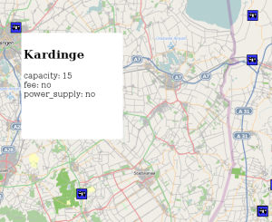
Ich habe eine OpenLayer Karte der Wohnmobil-Stellplätze aus OpenStreetMap-Daten erstellt (Datenstand OSM vom 02.03.2024, nur Europa) um die Tourplanung anhand der Wohnmobil-Stellplätze aus OpenStreetMap zu ermöglichen.
Würde mich über Anmerkungen, Tipps und Wünsche zur OpenLayer Karte freuen (bitte auf meiner Diskussionsseite).
Und so sieht das ganze aus:
Alternativ kann zur Darstellung der Stellplätze auch die Open Camping Map oder MapComplete (weltweite Darstellung) genutzt werden.
RV parks extracted from OSM
RV parks [3] or motorhome stopover sites [4] are labeled by tourism=caravan_site in OpenStreetMap. To make these data available for travel with motorhomes, I have extracted RV parks from OSM and provide here POI files for satnavs and a map for route planning.
Corrections on the RV parks can be done directly in the OpenStreetMap database. Adding RV parks is also possible (manual).
For further explanations about the information used for RV parks look at tourism=caravan_site
Garmin
Garmin offers the software PoiLoader (Freeware, Windows) to send POI data to the satnav devices. For some devices it is also possible to put the POI files directly on the device (in the subfolder 'Poi' in the folder 'Garmin') in mass storage mode (see POI on Garmin):
- csv file: The file poi_garmin_iso8859.csv can be read by the software 'PoiLoader' (data extracted from OSM: 02.03.2024).
- gpi file: Can be transferred directly to the memory of the device (data extracted from OSM: 27.05.2023).
TomTom
The file format for POI files on TomTom devices is *.ov2. These files can be obtained from Ascii files with the software 'MakeOv2' (Freeware, Windows).
- asc file: Can be read by the software 'MakeOv2' (data extracted from OSM: 02.03.2024).
- ov2 file: Can be transferred directly to the memory of the device (data extracted from OSM: 02.03.2024).
Others
Using the csv file for Garmin devices or the asc file for TomTom devices it should be possible to create POI files for devices of most manufacturers. Both files are text files (utf-8) in which the fields are separated by comma. On Garmin devices it is possible to add line breaks for the comment field (which was done in the *.csv file for Garmin). This is not possible for TomTom devices. So, if your device can deal with breaks in the comment field use the Garmin csv file, otherwise use the TomTom asc file.
With GPSBabel [5] it is possible to generate a kml file from the Garmin gpi file (z.B. gpsbabel -i garmin_gpi -f caravan_sites.gpi -o kml -F caravan_sites.kml). The kml file can be used for satnavs by Alpine, Kenwood, Pioneer, Zenec ... .
If other formats are needed, make a note at my talk page!
OpenLayer map with RV parks from OSM (Europe only)
I have created an OpenLayer map of the RV parks from OpenStreetMap (data extracted from OSM: 02.03.2024, Europe only). With this map I want to provide a possibility for tour planning with RVs.
Please use for comments my talk page.
An alternative map with RV parks (worldwide) is the Open Camping Map or the MapComplete.
