User:Nakaner/Cadastre Style
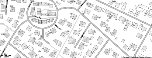
Walking Papers are often used for mapping addresses. Because the default map styles are very colourful, they are not very suitable for mapping addresses if you want to map the usage of buildings at the same time. To find a remedy, I provide a Maperitive map style which is only black and white. It is similar to official cadastre plans in Germany.
Specific Features and Avantages
- The style is black and white only because this is cheaper to print. Because it is not coloured, notes can be made with color coloured pens in field. These notes can easily be read.
- Rendering of buildings and their usage is similar to official German cadastre plans (deutsch: Liegenschaftskarte).
- The style uses as little with colour (grey) filled areas because it can be easier written on areas that are not printed than on printed areas (especially with laser printers) with hard pencils.
- Only the feature which are needed for mapping buildings and addresses are rendered. There are only four different types for roads and streets.
- Er rendert nur das, was man für das Adress- und Gebäudenutzungsmapping benötigt. Es wird nur nach vier verschiedenen Straßengruppen unterschieden (motorway + trunk, primary ... unclassified, residential + living_street, service, track, footways). POIs are not rendered.
Usage of Buildings
In some official German cadastre plans the house number of a residential building is aligned with the street the building belongs to. The hatchure of residential buildings is ascending relative to the street the building belongs to. All other buildings are hatched upright. This kind hatchure cannot be fully supported by this style because Maperitive cannot do so.
Hatchures
This Maperitive style uses following hatchures.
| Hatchure | Meaning | Tags |
|---|---|---|
| ascending |
residential building | building=residential, building=apartments, building=dormitory, building=house, building=terrace, building=detached |
| upright |
other usage than residential which is given by the abbrevation | building=garage, building=kindergarten, building=yes + amenity=kindergarten u.v.a.m. |
| no hatchure | unknown usage | building=yes apart from some area-POIs, e.g. building=yes + amenity=kindergarten |
There is also a variant without hatchures.
Abbrevations
How a building is used is given by abbrevation which are from Verwaltungsvorschrift für die Führung des Liegenschaftskatasters in Baden-Württemberg vom 5. Dezember 2012, Anlage 2 (English: Administrative Directive for keeping the land survey records in the state of Baden-Württemberg, Germany by December 5, 2012, annexe 2, pdf page 107) The tag building:type=* is not interpreted by this rendering style. The abbrevations are German.
| Abbrevation | Meaning | Tags |
|---|---|---|
| Btrg | commercial or service building (all kinds of buildings which are almost only use commercial | building=service or building=commercial |
| Fabr | factory building | building=industrial |
| Gar | garage, garages | building=garage, building=garages |
| Hand | business house (trade), retail | building=retail |
| Hochsch | university building | building=university or building=yes + amenity=university |
| Kiga | kindergarten | building=kindergarten or building=yes + amenity=kindergarten |
| Kirche | church or chapel | building=church oder an einem geschlossenen Way amenity=place_of_worship + religion=christian |
| Krhs | hospital | building=hospital |
| Lagg | storage building | building=warehouse |
| Schule | school | building=school oder building=yes + amenity=school |
| Schr | barn | building=barn |
| Vord | porch roof or a building which is open to one or mode sides (is usually not beeing recorded in official land survey records in Baden Württemberg and other German states) | building=roof |
| Wirtg | building for farming | building=farm |
| Whs | building with residential usage or dormitory | building=residential, building=apartments, amenity=dormitory, amenity=house, amenity=terrace, amenity=detached |
| usage not mapped | building=yes or building=* |
Development
Missing Features
- channels, ditches, docks
- land marks etc. (isolated trees, fences)
- building entrances
- oneways streets
- railway bridges
- administrative borders
Known Issues
- If you want to make a svg file with this style, you will have to use the command export-svg with compatibility=Illustrator.
- If you convert the svg file with Inkscape into a pdf, all buildings will be filled with black colour and not be hatched. I suggest Firefox for viewing and printing. You can use a hatchure-free alternative, too.
Discussion
Please discuss and ask questions at discussion page.
Sources and License
The sources are available at Github. Pull-request are welcome. Both style sheets (with and without hatchures) are licensed under Creative Commons Attribution Share-Alike 2.0 or newer (CC-BY-SA 2.0+).
