Philippines/Featured images
The selection of images to be featured occurs at the Nominations subpage. Go and nominate one! Images are generally promoted to featured status every week on Sundays, but only if someone can be bothered to do so. :-)
These featured images provide a ready collection of images that can be used for promoting OpenStreetMap in the Philippines. They are also used to inspire and encourage Filipino OpenStreetMappers to continue mapping and having fun!
You might also be interested in the global Featured images project which showcases pictures, photos, and illustrations of OpenStreetMap from around the world. That project actually inspired this Philippine-specific featured images sub-project. Some of the images below are actually featured there as well.
Archives
Images
| Week | Image | Description | Global featured image? |
|---|---|---|---|
| Jan 4 | 
|
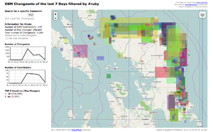
Typhoon Ruby changesets. Similar to 2013 Typhoon Haiyan, the international OSM community did a HOT activation to help map areas affected by Typhoon Hagupit, also known as Typhoon Ruby in the Philippines. This image shows the bounding boxes of changesets tagged with #ruby concentrated along the northeast coastline of the island of Samar. |
| |||||||||||||||||||||||||||||||||||||||||

