Zh-hans:Featured images/Oct-Dec 2016
Jump to navigation
Jump to search


这是特色图片,展现开放街图画地图范例,以及最能代表开放街图的专案。
如果你知道其他有类似品质的图片,你可以在特色图片提名处(en)提名。
| ← 从2015年10月到12月 | ← 从2016年7月到9月 | 从2017年1月到3月 → | 从2017年10月到12月 → |
特色图片库、从2016年10月到12月
2016年、第40周

2016年、第41周

2016年、第42周
2016年、第43周
2016年、第44周
2016年、第45周

2016年、第46周

2016年、第47周
2016年、第48周

2016年、第49周
2016年、第50周
2016年、第51周
2016年、第52周
细节和字幕
第40周(从2016年10月3日星期一到2016年10月9日星期日) [Edit]

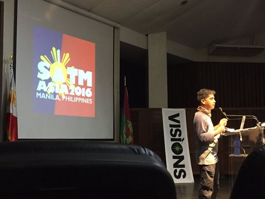
- English : Opening session at State of the Map Asia 2016 in Manila, Philippines last weekend.
- 中文(简体) : 上周末在菲律宾马尼拉举行的State of the Map Asia 2016开幕式。
第41周(从2016年10月10日星期一到2016年10月16日星期日) [Edit]

- English : Marco Barbieri presented his cartographic work at OSMit last year, producing these attractive web maps (webmapp.it) and printable tourist maps of Monte Pisano, as well as organising mapping parties in this part of Italy.
- 中文(简体) : Marco Barbieri 在去年OSMit上发表他的地图设计工作,创造这几个吸引人的网路地图([ http://webmapp.it webmapp.it]),还有推出可列印的Monte Pisano旅游地图,当然还有在义大利这块地方办图客趴。
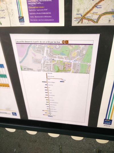
第42周(从2016年10月17日星期一到2016年10月23日星期日) [Edit]

- English : The public transport service STAR in Rennes Metropole, France, uses OpenStreetMap on their information boards.
- 中文(简体) : 法国雷恩一带当地的"STAR"巴士服务,资讯立版使用开放街图。
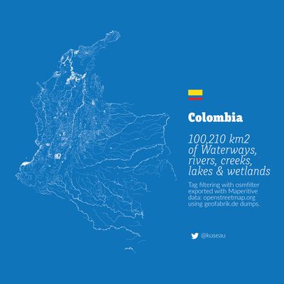
第43周(从2016年10月24日星期一到2016年10月30日星期日) [Edit]

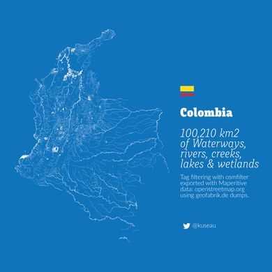
- English : A beautiful image showing all the rivers, lakes, creeks and wetlands of Colombia by Omar Pineda.
- 中文(简体) : 这张显示所有哥伦比亚的河川、湖泊、小溪和湿地的地图,由Omar Pineda制作。
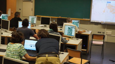
第44周(从2016年10月31日星期一到2016年11月6日星期日) [Edit]

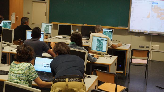
- English : This mapathon in Valencia, Spain, was one of many worldwide disaster response mapping events taking place in response to Hurricane Matthew.
- 中文(简体) : 这次在西班牙巴伦西亚举行的mapathon,是众多在世界各地为了飓风马修,举行的灾难救护画地图活动。
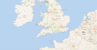
第45周(从2016年11月7日星期一到2016年11月13日星期日) [Edit]

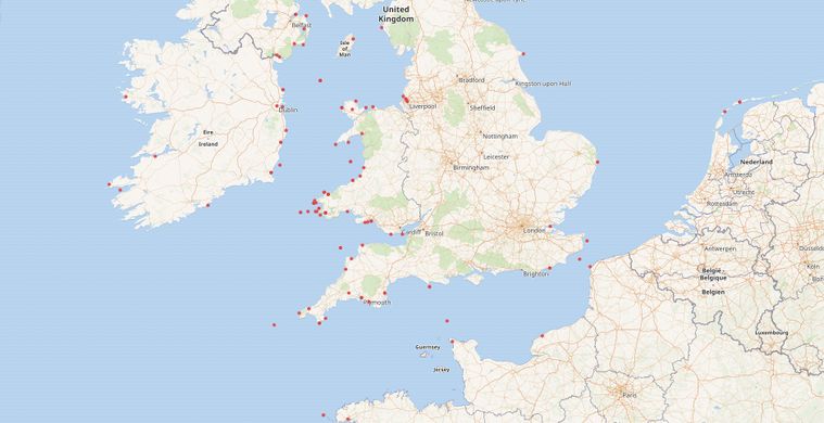
- English : The WikiData project has an eclectic mix of linked datasets and provides a querying interface which can yield a map. This example by Jason Evans shows positions of 19th century Aberystwyth ships wrecked at sea, using data from National Library of Wales and the Ceredigion Archives.
- 中文(简体) : WikiData专案具有混合组合的连接资料集,并且提供可以产生地图的查询界面。 Jason Evans的这个例子,使用威尔士国家图书馆和锡尔迪金档案库资料,显示19世纪阿伯里斯特威斯船在海上失事的位置。
第46周(从2016年11月14日星期一到2016年11月20日星期日) [Edit]

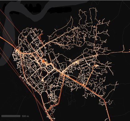
- English : Interchange Choreography by Nicholas Rougeux, is an artistic exploration of major road intersections "Applying colors to roads and using connecting roads to blend those colors".
- 中文(简体) : 由Nicholas Rougeux制作的交换编舞,是用艺术家的方式探索主要道路交叉,「将道路上色,而且连接道路时会混色」。
第47周(从2016年11月21日星期一到2016年11月27日星期日) [Edit]

- English : Take open data from OpenStreetMap and have it turned into a stylish and unique pendant on meshu.io!
- 中文(简体) : 拿开放街图的开放资料,在meshu.io订制有造型而且特别的吊坠!
第48周(从2016年11月28日星期一到2016年12月4日星期日) [Edit]

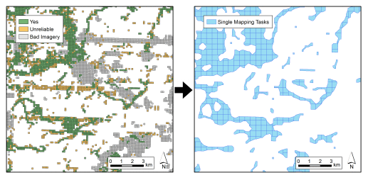
- English : Many people have been classifying imagery in a new super-simple micro-tasking app called MapSwipe. This image illustrates a process developed by DisasterMappers Heidelberg for taking MapSwipe results (left) and setting up a Task Manager project to map the settlements (right).
- 中文(简体) : 很多民众透过超级简单的微任务 app MapSwipe 来帮忙影像分类。这张图片显示由海德堡灾难绘图者制订的流程,来处理MapSwipe 的结果(左),以及依据上面得到的结果来设任务管理员专案,绘制发现的聚落(右)。
第49周(从2016年12月5日星期一到2016年12月11日星期日) [Edit]

- English : State of the Map Latam 2016, the conference for Latin America, took place last week in São Paulo.
- 中文(简体) : State of the Map Latam 2016是拉丁美洲的社群大会,上周在圣保罗举行。
第50周(从2016年12月12日星期一到2016年12月18日星期日) [Edit]

- English : Local volunteers trained by the American Red Cross have mapped 7,000 villages in the border regions of Liberia, Guinea, and Sierra Leone. A total of 70,000 kilometres of roads and paths, including this example, Forécariah in Guinea.
- 中文(简体) : 由红十字会训练的在地志工绘制利比里亚、几内亚、塞拉利昂边境一带7,000 个村庄,并且绘制总长超过70,000 公里的道路和路径,包括图中的例子,几内亚的Forécariah。
第51周(从2016年12月19日星期一到2016年12月25日星期日) [Edit]

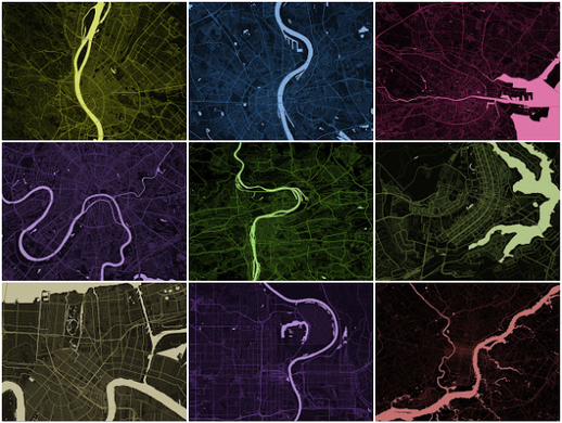
- English : These stripped down maps elegantly characterise world cities by highlighting the shape of water features. They were created by Alex Szabo-Haslam and recently featured in a guardian cities quiz. How many do you recognise?
- 中文(简体) : 这些截取的地图藉由强调水体形状的图征,优雅的呈现世界各地的城市。Alex Szabo-Haslam创造这些图,并在a 卫报的城市小测验出现。你认得几个城市呢?
第52周(从2016年12月26日星期一到2017年1月1日星期日) [Edit]

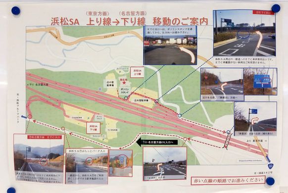
- English : A poster about how to make a U-turn at Hamamatsu highway service area, made by the Shizuoka prefecture, Japan.
- 中文(简体) : 由日本静冈县政府制作的告示牌,告知要如何在滨松高速公路休息区回转。