ArcGIS Editor for OSM
| ArcGIS Editor for OSM | ||||||||||||||||||||||||||||||||||||||||||||||||||||||||||||||||||||||||||||||||||||||||||||||||||||||||||||||||||||||||||||||||
|---|---|---|---|---|---|---|---|---|---|---|---|---|---|---|---|---|---|---|---|---|---|---|---|---|---|---|---|---|---|---|---|---|---|---|---|---|---|---|---|---|---|---|---|---|---|---|---|---|---|---|---|---|---|---|---|---|---|---|---|---|---|---|---|---|---|---|---|---|---|---|---|---|---|---|---|---|---|---|---|---|---|---|---|---|---|---|---|---|---|---|---|---|---|---|---|---|---|---|---|---|---|---|---|---|---|---|---|---|---|---|---|---|---|---|---|---|---|---|---|---|---|---|---|---|---|---|---|---|
 | ||||||||||||||||||||||||||||||||||||||||||||||||||||||||||||||||||||||||||||||||||||||||||||||||||||||||||||||||||||||||||||||||
| Author: | Esri | |||||||||||||||||||||||||||||||||||||||||||||||||||||||||||||||||||||||||||||||||||||||||||||||||||||||||||||||||||||||||||||||
| License: | Apache License 2.0 | |||||||||||||||||||||||||||||||||||||||||||||||||||||||||||||||||||||||||||||||||||||||||||||||||||||||||||||||||||||||||||||||
| Platforms: | Windows, Windows 2000, Windows XP, Windows Mobile, and Windows Mobile 2003 | |||||||||||||||||||||||||||||||||||||||||||||||||||||||||||||||||||||||||||||||||||||||||||||||||||||||||||||||||||||||||||||||
| Status: | Active | |||||||||||||||||||||||||||||||||||||||||||||||||||||||||||||||||||||||||||||||||||||||||||||||||||||||||||||||||||||||||||||||
| Version: | 10.8 releases (2022-05-05) | |||||||||||||||||||||||||||||||||||||||||||||||||||||||||||||||||||||||||||||||||||||||||||||||||||||||||||||||||||||||||||||||
| Language: | English
| |||||||||||||||||||||||||||||||||||||||||||||||||||||||||||||||||||||||||||||||||||||||||||||||||||||||||||||||||||||||||||||||
| Website: | https://github.com/Esri/arcgis-osm-editor | |||||||||||||||||||||||||||||||||||||||||||||||||||||||||||||||||||||||||||||||||||||||||||||||||||||||||||||||||||||||||||||||
| Source code: | https://github.com/Esri/arcgis-osm-editor | |||||||||||||||||||||||||||||||||||||||||||||||||||||||||||||||||||||||||||||||||||||||||||||||||||||||||||||||||||||||||||||||
| Programming languages: | C# and Python | |||||||||||||||||||||||||||||||||||||||||||||||||||||||||||||||||||||||||||||||||||||||||||||||||||||||||||||||||||||||||||||||
|
Allows users to download, edit, and upload OSM data in ArcMap, and/or create feature services based on OSM data in ArcGIS Server | ||||||||||||||||||||||||||||||||||||||||||||||||||||||||||||||||||||||||||||||||||||||||||||||||||||||||||||||||||||||||||||||||
| ||||||||||||||||||||||||||||||||||||||||||||||||||||||||||||||||||||||||||||||||||||||||||||||||||||||||||||||||||||||||||||||||
ArcGIS now has the ability to import and export OSM data via a free add-in for ArcMap (up to 10.7.x) as well as an extension for ArcGIS Server.
You can download the OSM Editor plug-in here:
Download
The add-in was released by Esri in July 2010. It is free open source, hosted on GitHub and under the Apache License.
Installation and setup
To use the ArcGIS Editor for OSM, you must first have ArcGIS Desktop installed. After installing ArcGIS Desktop, download the extension, and follow instructions for installation.
Using
There are many tools in the ArcGIS Editor for OSM toolbox, but the two most oft-used ones are for 1) Downloading from OSM and then 2) Uploading edits back to OSM (see the Editor's Getting Started documentation). What happens in-between is editing the downloaded data. Users can leverage the many editing and analysis tools available in ArcGIS Desktop to do their editing or run analysis/use the downloaded data. Editing tools such as parcel editing, topology tools, and network analysis provide ways to powerfully edit and use the data.
Upcoming functionality (version 2.0) will also provide a feature service capability, such that ArcGIS Server Feature services can be easily created and support editing from a variety of clients. See What's Next for ArcGIS Editor for OSM for details.
ESRI have said that you are allowed to use imagery provided by ESRI for tracing. A Github issue was opened in late 2015 to try clarifying the situation, and this was answered in August 2017 by ESRI on its blog.
In ArcGIS Desktop 10, you can also Openstreetmap as a basemap to the map document, which is useful for seeing what work has already been done in an area before you download and edit the data from OSM. Using the Bing aerial imagery basemap in ArcGIS Desktop to derive vector data for OSM is possible (although legally may not be endorsed by Esri). See the Bing page for details.
Screenshots
-
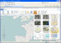
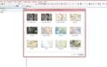 ArcGIS showing the different basemaps available
 -
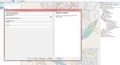
 Showing how ArcGIS can download OSM data
 -
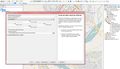
 ArcGIS showing the different layer properties of OSM data
 -
 ArcGIS showing the OSM Plugin Toolbox, with various choices
 -
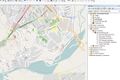
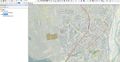
 Viewing the shkoder area in ArcMap 10.0
 -
 ArcGIS showing how to upload data to OSM
 -
 ArcGIS showing OSM Mapnik with Bing Maps's aerial imagery as a transparent overlay
 -
 Screenshot of ArcGIS Explorer Online (requires Microsoft Silverlight)


