Bourne
| V・T・E |
| latitude: 52.768015, longitude: -0.377139 |
| Browse map of Bourne 52°46′04.85″ N, 0°22′37.70″ W |
| Edit map |
|
External links:
|
| Use this template for your locality |
Bourne is a town in Lincolnshire at latitude 52°46′04.85″ North, longitude 0°22′37.70″ West.
Description
Bourne is a market town located on the edge of the Fens, with a population of approximately 18,000[1]. The Bourne Eau waterway starts in the Wellhead Pond, and flows through the town, although parts run through culverts (notably along Coggle's Causeway). Bourne Woods is one of the largest forests in South Lincolnshire, and is the town's main attraction. Other notable attractions include Baldock's Mill (currently open to the public as a museum), Bourne Abbey (in use as a parish church), the Red Hall (closed to the public, owned by the Bourne United Charities). The Wellhead Fields is the primary park, on which the castle previously stood (only earthworks survive)[2]. Bourne has a leasure centre (located next to Bourne Academy), several supermarkets (and there are plans to build an Aldi on the western roundabout), an outdoor swimming pool (at Abbey Lawn), and two secondary schools, one of which is a grammar school. Bourne also has a number of closed pubs.[3]
Bourne sits on the route of King Street, a Roman Road that passed by the Abbey Church and Meadowgate.[4] The present route on OpenStreetMap is inaccurate in the area of Bourne, and needs updating. The Roman canal Car Dyke also passes through Bourne, and flows into the Bourne Eau. It is accurately mapped (along with its previous course), but there are no water areas in sections, and fields around it are not mapped.
Bourne sits on the A15 road from Peterborough to Lincoln, and other roads run to Stamford (A6121), Colsterworth (A151 westbound), Spalding (A151 eastbound), and Tongue End (South Fen Road). Bourne is serviced by several bus services from Delaine, of which two are partially mapped, and all others are not mapped at all. There are also a number of now disused bus stops mapped, which need to be retagged.[5]
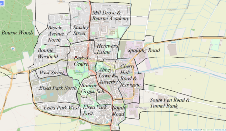
Progress

| Name | Buildings | Detailing | Notes |
|---|---|---|---|
| Park & Centre | all | good | |
| Stanley Street | all | good | |
| Mill Drove & Bourne Academy | over two thirds | decent | better detailing in the north |
| Hereward Estate | all (crude - to redo) | very poor | |
| Spalding Road | all | decent | houses being built, will need adding |
| Cherry Holt Road & Eastgate | all | good | |
| South Fen Road & Tunnel Bank | all | poor | |
| Abbey Lawn & Austerby | all | good | |
| South Road | all | good | houses built, awaiting satellite imagery |
| Grammar School & Cemetery | all | good | |
| Elsea Park East | approx two thirds | decent | Folkestone Close is exemplary |
| Elsea Park West | approx one quarter | poor | |
| Elsea Park North | negligible | poor | houses being built, some finished, awaiting satellite imagery |
| West Street | all | decent | |
| Westfield | all | good | |
| Bourne Woods | all | decent | |
| Beech Avenue (North) | all | good |
Alignment is dubious and slightly mismatched throughout.
Subdivisions
Historically Bourne consisted of the town itself (Bourne, previously Bourn and Brune), Austerby and Eastgate. The parish also includes the villages of Cawthorpe (all buildings and good detail), Dyke (all buildings, but crude and little detail), Twenty (a couple buildings, no detailing), the (western half of the) hamlet of Guthram Gowt (all buildings, some detail), and numerous isolated dwellings and farms.
Currently most areas of the town proper do not have an official or commonly used name. Prominent areas that do are:
- Town Centre
- Austerby
- Eastgate
- Hereward Estate
- Elsea Park
- Westfield
Other areas tend to be named based on a prominent road running through the area (such as Mill Drove). Since these are often large, the subdivisions above have been used in order to make improvements more notable.
Conversation Area
Bourne contains a conservation area for historic buildings, with details shown in this document. A map (overlayed on OSM) is shown on South Kesteven District Council's website here. Since the license is unclear I have not added it to OSM. Prior to 2013 the conservation area had these boundaries. All buildings within the conservation area have been added to OpenStreetMap.
References
- ↑ https://www.citypopulation.de/en/uk/eastmidlands/admin/south_kesteven/E04005884__bourne/
- ↑ https://historicengland.org.uk/listing/the-list/list-entry/1005023?section=official-list-entry
- ↑ https://www.closedpubs.co.uk/lincolnshire/bourne.html
- ↑ http://www.falakros.net/bourne/portrait/romanbourne.htm
- ↑ https://www.delainebuses.com/timetables.html

