Category:Mapping state icon
Jump to navigation
Jump to search
Icons that are used by different wiki templates to indicate the mapping process of an area.
When adding files, please remember to append a useful name to the category definition, such as [[Category:Mapping state icon|Bus2]] so that we don't have all entries filed under "S" for "State".
Colour and symbol legend
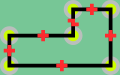
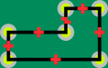
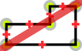
The status of each map region is indicated by a symbol, which describes the type of feature, and a colour, which indicates the completeness of that feature in a map region.
Usage
The status is displayed using a template Template:State
{{State|Key=progress}}- progress - 1/2/3/4/NA
Meaning of symbols
 - Street names are labelled. This means that the map can be used to find an address - Key: l
 - All housenumbers are present - Key: h
 - All footways are present - Key: fo
 - All wheelchair access is present - Key: d
 - All cycleways, and field and forest roads suitable for bicycles are present - Key: b
 - Roads for car traffic are present. One way streets and pedestrian streets are present. This means that the map can be used for car navigation - Key: c
 - All public transports are present (including name of the bus stop/station names) - Key: tr
 - All stop/station/harbour names are present - Key: ha
 - All bus lines are present (including name of the bus stop names) - Key: bu
 - All trolley/guided bus lines are present (including name of the station names) - Key: ty
 - All tram lines are present (including name of the tram station names) - Key: tm
 - All fast railway lines transports are present (including name of the train station names) - Key: tn
 - All U-Bahn (subway in Germany) lines are present (including name of the station names) - Key: u
 - All S-Bahn (regional commuter train in Germany) lines are present (including name of the station names) - Key: s
 - All steam railway lines transports are present (including name of the train station names) - Key: st
 - All ship lines are present (including name of the harbour station names) - Key: sh
 - All public institutions are present (Churches, sports facilities, venues, schools, hospitals, city hall) - Key: p
 - All emergency services (hospitals...) are present - Key: em
 - All petrol stations are present - Key: fu
 - All restaurants and hotels are present - Key: r
 - All tourist attractions are present - Key: t
 - All natural resources are mapped (e.g Water, Lakes and Woodland) - Key: n
Meaning of colours
| Background colour | Meaning | Use for navigation | To do | value |
|---|---|---|---|---|
| The map needs checking, status unknown | Availability unknown | Please check | (None) | |
| The map contains no or little data | Not to be used | Please complete | 0 | |
| The map contains partial data | Limited usability | Please complete | 1 | |
| The map is largely complete (please describe missing data) | Use with restrictions | Please complete (missing data, streets etc.) | 2 | |
| The map is complete (in the opinion of a mapper) | Suitable for use | Please check and correct any errors | 3 | |
| The map is complete (verified by 2 mappers) ; please indicate Date when checked) | Suitable for use | Please update as needed | 4 | |
| This attribute does not exist in the mapped area (e.g. no petrol stations) | Suitable for use | Please update as needed | X |
The English translation is Editable here.
Subcategories
This category has the following 2 subcategories, out of 2 total.
Media in category "Mapping state icon"
The following 200 files are in this category, out of 519 total.
(previous page) (next page)-
 State .svg 32 × 20; 947 bytes
-
 State 0.svg 32 × 20; 947 bytes
-
 State 1.svg 32 × 20; 947 bytes
-
 State 2.svg 32 × 20; 947 bytes
-
 State 3.svg 32 × 20; 947 bytes
-
 State 4.svg 32 × 20; 947 bytes
-
 State X.svg 32 × 20; 1 KB
-
 State Alpine-Hut.svg 32 × 20; 4 KB
-
 State Alpine-Hut0.svg 32 × 20; 4 KB
-
 State Alpine-Hut1.svg 32 × 20; 4 KB
-
 State Alpine-Hut2.svg 32 × 20; 4 KB
-
 State Alpine-Hut3.svg 32 × 20; 4 KB
-
 State Alpine-Hut4.svg 32 × 20; 4 KB
-
 State Alpine-HutX.svg 32 × 20; 4 KB
-
 State Artwork.svg 32 × 20; 3 KB
-
 State Artwork0.svg 32 × 20; 3 KB
-
 State Artwork1.svg 32 × 20; 3 KB
-
 State Artwork2.svg 32 × 20; 3 KB
-
 State Artwork3.svg 32 × 20; 3 KB
-
 State Artwork4.svg 32 × 20; 3 KB
-
 State ArtworkX.svg 32 × 20; 3 KB
-
 State Bike.svg 32 × 20; 1 KB
-
 State Bike0.svg 32 × 20; 1 KB
-
 State Bike1.svg 32 × 20; 1 KB
-
 State Bike2.svg 32 × 20; 1 KB
-
 State Bike3.svg 32 × 20; 1 KB
-
 State Bike4.svg 32 × 20; 1 KB
-
 State BikeX.svg 32 × 20; 2 KB
-
 State Blind.svg 32 × 20; 799 bytes
-
 State Blind0.svg 32 × 20; 933 bytes
-
 State Blind1.svg 32 × 20; 933 bytes
-
 State Blind2.svg 32 × 20; 933 bytes
-
 State Blind3.svg 32 × 20; 933 bytes
-
 State Blind4.svg 32 × 20; 933 bytes
-
 State BlindX.svg 32 × 20; 1 KB
-
 State Bridge.svg 32 × 20; 412 bytes
-
 State Bridge0.svg 32 × 20; 414 bytes
-
 State Bridge1.svg 32 × 20; 414 bytes
-
 State Bridge2.svg 32 × 20; 414 bytes
-
 State Bridge3.svg 32 × 20; 414 bytes
-
 State Bridge4.svg 32 × 20; 414 bytes
-
 State BridgeX.svg 32 × 20; 575 bytes
-
 State Building.svg 32 × 20; 492 bytes
-
 State Building0.svg 32 × 20; 494 bytes
-
 State Building1.svg 32 × 20; 494 bytes
-
 State Building2.svg 32 × 20; 494 bytes
-
 State Building3.svg 32 × 20; 494 bytes
-
 State Building4.svg 32 × 20; 494 bytes
-
 State BuildingX.svg 32 × 20; 655 bytes
-
 State Building Outline.svg 32 × 20; 3 KB
-
 State Building Outline0.svg 32 × 20; 3 KB
-
 State Building Outline1.svg 32 × 20; 3 KB
-
 State Building Outline2.svg 32 × 20; 3 KB
-
 State Building Outline3.svg 32 × 20; 3 KB
-
 State Building Outline4.svg 32 × 20; 3 KB
-
 State Building OutlineX.svg 32 × 20; 3 KB
-
 State Buildings.svg 32 × 20; 1 KB
-
 State Buildings0.svg 32 × 20; 1 KB
-
 State Buildings1.svg 32 × 20; 1 KB
-
 State Buildings2.svg 32 × 20; 1 KB
-
 State Buildings3.svg 32 × 20; 1 KB
-
 State Buildings4.svg 32 × 20; 1 KB
-
 State BuildingsX.svg 32 × 20; 1 KB
-
 State Buoy.svg 32 × 20; 704 bytes
-
 State Buoy0.svg 32 × 20; 706 bytes
-
 State Buoy1.svg 32 × 20; 706 bytes
-
 State Buoy2.svg 32 × 20; 706 bytes
-
 State Buoy3.svg 32 × 20; 706 bytes
-
 State Buoy4.svg 32 × 20; 706 bytes
-
 State BuoyX.svg 32 × 20; 867 bytes
-
 State Bus.svg 32 × 20; 8 KB
-
 State Bus0.svg 32 × 20; 8 KB
-
 State Bus1.svg 32 × 20; 8 KB
-
 State Bus2.svg 32 × 20; 8 KB
-
 State Bus3.svg 32 × 20; 8 KB
-
 State Bus4.svg 32 × 20; 8 KB
-
 State BusX.svg 32 × 20; 8 KB
-
 State Camping.svg 32 × 20; 2 KB
-
 State Camping0.svg 32 × 20; 2 KB
-
 State Camping1.svg 32 × 20; 2 KB
-
 State Camping2.svg 32 × 20; 2 KB
-
 State Camping3.svg 32 × 20; 2 KB
-
 State Camping4.svg 32 × 20; 2 KB
-
 State CampingX.svg 32 × 20; 2 KB
-
 State Car.svg 32 × 20; 2 KB
-
 State Car0.svg 32 × 20; 2 KB
-
 State Car1.svg 32 × 20; 2 KB
-
 State Car2.svg 32 × 20; 2 KB
-
 State Car3.svg 32 × 20; 2 KB
-
 State Car4.svg 32 × 20; 2 KB
-
 State CarX.svg 32 × 20; 2 KB
-
 State Class.svg 32 × 20; 15 KB
-
 State Class0.svg 32 × 20; 15 KB
-
 State Class1.svg 32 × 20; 15 KB
-
 State Class2.svg 32 × 20; 15 KB
-
 State Class3.svg 32 × 20; 15 KB
-
 State Class4.svg 32 × 20; 15 KB
-
 State ClassX.svg 32 × 20; 15 KB
-
 State Detours.svg 32 × 20; 1 KB
-
 State Detours0.svg 32 × 20; 1 KB
-
 State Detours1.svg 32 × 20; 1 KB
-
 State Detours2.svg 32 × 20; 1 KB
-
 State Detours3.svg 32 × 20; 1 KB
-
 State Detours4.svg 32 × 20; 1 KB
-
 State DetoursX.svg 32 × 20; 2 KB
-
 State Draft.svg 32 × 20; 7 KB
-
 State Draft0.svg 32 × 20; 7 KB
-
 State Draft1.svg 32 × 20; 7 KB
-
 State Draft2.svg 32 × 20; 7 KB
-
 State Draft3.svg 32 × 20; 7 KB
-
 State Draft4.svg 32 × 20; 7 KB
-
 State DraftX.svg 32 × 20; 7 KB
-
 State emergency.svg 32 × 20; 491 bytes
-
 State emergency0.svg 32 × 20; 493 bytes
-
 State emergency1.svg 32 × 20; 493 bytes
-
 State emergency2.svg 32 × 20; 493 bytes
-
 State emergency3.svg 32 × 20; 493 bytes
-
 State emergency4.svg 32 × 20; 493 bytes
-
 State emergencyX.svg 32 × 20; 655 bytes
-
 State Exit.svg 32 × 20; 2 KB
-
 State Exit0.svg 32 × 20; 2 KB
-
 State Exit1.svg 32 × 20; 2 KB
-
 State Exit2.svg 32 × 20; 2 KB
-
 State Exit3.svg 32 × 20; 2 KB
-
 State Exit4.svg 32 × 20; 2 KB
-
 State ExitX.svg 32 × 20; 2 KB
-
 State Exitnr.svg 32 × 20; 2 KB
-
 State Exitnr0.svg 32 × 20; 2 KB
-
 State Exitnr1.svg 32 × 20; 2 KB
-
 State Exitnr2.svg 32 × 20; 2 KB
-
 State Exitnr3.svg 32 × 20; 2 KB
-
 State Exitnr4.svg 32 × 20; 2 KB
-
 State ExitnrX.svg 32 × 20; 2 KB
-
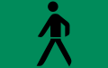
 State Foot.svg 32 × 20; 947 bytes
-
 State Foot0.svg 32 × 20; 949 bytes
-
 State Foot1.svg 32 × 20; 949 bytes
-
 State Foot2.svg 32 × 20; 949 bytes
-
 State Foot3.svg 32 × 20; 949 bytes
-
 State Foot4.svg 32 × 20; 949 bytes
-
 State FootX.svg 32 × 20; 999 bytes
-
 State Forest.svg 32 × 20; 895 bytes
-
 State Forest0.svg 32 × 20; 897 bytes
-
 State Forest1.svg 32 × 20; 897 bytes
-
 State Forest2.svg 32 × 20; 897 bytes
-
 State Forest3.svg 32 × 20; 897 bytes
-
 State Forest4.svg 32 × 20; 897 bytes
-
 State ForestX.svg 32 × 20; 1 KB
-
 State Frame.svg 32 × 20; 351 bytes
-
 State Frame0.svg 32 × 20; 317 bytes
-
 State Frame1.svg 32 × 20; 317 bytes
-
 State Frame2.svg 32 × 20; 317 bytes
-
 State Frame3.svg 32 × 20; 317 bytes
-
 State Frame4.svg 32 × 20; 317 bytes
-
 State FrameX.svg 32 × 20; 479 bytes
-
 State Fuel.svg 32 × 20; 2 KB
-
 State Fuel0.svg 32 × 20; 2 KB
-
 State Fuel1.svg 32 × 20; 2 KB
-
 State Fuel2.svg 32 × 20; 2 KB
-
 State Fuel3.svg 32 × 20; 2 KB
-
 State Fuel4.svg 32 × 20; 2 KB
-
 State FuelX.svg 32 × 20; 2 KB
-
 State Hazmat.svg 32 × 20; 4 KB
-
 State Hazmat0.svg 32 × 20; 4 KB
-
 State Hazmat1.svg 32 × 20; 4 KB
-
 State Hazmat2.svg 32 × 20; 4 KB
-
 State Hazmat3.svg 32 × 20; 4 KB
-
 State Hazmat4.svg 32 × 20; 4 KB
-
 State HazmatX.svg 32 × 20; 4 KB
-
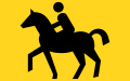
 State Horse.svg 32 × 20; 2 KB
-
 State Horse0.svg 32 × 20; 2 KB
-
 State Horse1.svg 32 × 20; 2 KB
-
 State Horse2.svg 32 × 20; 2 KB
-
 State Horse3.svg 32 × 20; 2 KB
-
 State Horse4.svg 32 × 20; 2 KB
-
 State HorseX.svg 32 × 20; 2 KB
-
 State Hotel.svg 32 × 20; 1 KB
-
 State Hotel0.svg 32 × 20; 1 KB
-
 State Hotel1.svg 32 × 20; 1 KB
-
 State Hotel2.svg 32 × 20; 1 KB
-
 State Hotel3.svg 32 × 20; 1 KB
-
 State Hotel4.svg 32 × 20; 1 KB
-
 State HotelX.svg 32 × 20; 2 KB
-
 State Housenumbers.svg 32 × 20; 742 bytes
-
 State Housenumbers0.svg 32 × 20; 744 bytes
-
 State Housenumbers1.svg 32 × 20; 744 bytes
-
 State Housenumbers2.svg 32 × 20; 744 bytes
-
 State Housenumbers3.svg 32 × 20; 744 bytes
-
 State Housenumbers4.svg 32 × 20; 744 bytes
-
 State HousenumbersX.svg 32 × 20; 905 bytes
-
 State Labelled.svg 32 × 20; 3 KB
-
 State Labelled0.svg 32 × 20; 3 KB
-
 State Labelled1.svg 32 × 20; 3 KB
-
 State Labelled2.svg 32 × 20; 3 KB
-
 State Labelled3.svg 32 × 20; 3 KB
-
 State Labelled4.svg 32 × 20; 3 KB
-
 State LabelledX.svg 32 × 20; 4 KB
-
 State Lamp.svg 32 × 20; 3 KB
-
 State Lamp0.svg 32 × 20; 3 KB
-
 State Lamp1.svg 32 × 20; 3 KB
-
 State Lamp2.svg 32 × 20; 3 KB


