Connecticut/Western COG Building Import
Duration: 16 Sep 2020 - 24 Jan 2021
Current progress: 100%
Participating users: Mashin, roptat
Import account: CT-import
| STATUS: Completed |
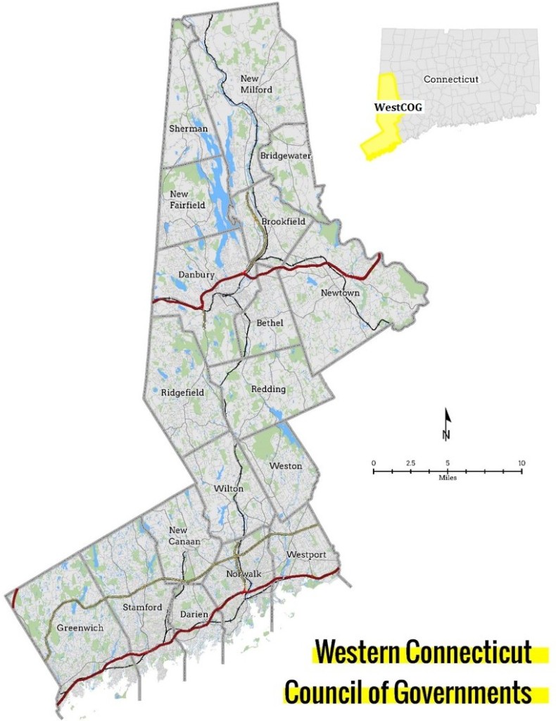
Connecticut is a State in the United States of America. Most of its buildings are still missing from the map. Buildings were completed from imagery in New Haven after a huge effort from the local community, and in other smaller areas across the state. The community in New Haven (and surrounding areas) would like to import building data for the state.
Different data sources with compatible licenses were considered:
- Microsoft's building footprints, lack quality and would require a manual fix to almost every building, making it impractical and even worse than a manual drawing from aerial imagery
- Connecticut data, is of good quality, but needs simplifications, most of the buildings still need to be fixed manually
- Data from Councils of Governments (COG), of good quality and precision, but each COG needs to be contacted individually.
As a start, we plan to import the Western COG Building Data, as it is readily available for download from their website, of good quality and precision, under a compatible license.
Area where buildings will be imported: Southwest CT
Link for download: WestCOG building footprint data.
A small sample of data in .shp file that can can be loaded in JOSM can be dowloaded here.
WestCOG was asked for permission to import building footprint data it in OSM.
In addition addresses for some buildings was extracted from CT Open Data dataset. These will be imported as separate points inside the building polygon.
Data

Original data transformed to WGS84 as .shp file is available here.
Converted building outlines and address points (see Methodology) as .GeoJSON file is available here.
Converted building outlines and address points [Westport] : Small sample of the data loadable into JOSM.
Converted data consists of:
311,620 Buildings
296,405 Building:parts
3,542,624 Nodes
4,150,649 Objects total
160,591 Address points
License Requirement
Building footprint data
As licensing information is missing from their website, we have contacted Western COG to enquire about license requirements. Here is a copy of part of the exchange:
OSM [March 4, 2020 2:15pm]:
I am a member of OpenStreetMap community. OpenStreetMap is a collection of geospatial data created by collaborative effort of thousands of members around the world that can be used to create maps and is available to everybody for free. In a sense it is a Wikipedia of maps.I am writing you, because I would like to ask you about availability of building footprint data [1]. I looked at the linked data, but I couldn’t find any description of a license. Since COGs are publicly funded, is it possible that they are under public license? If not, would there be any possibility to obtain a permission to use them for import into OpenStreetMap database?
OSM data are afterwards provided under ODbL license: https://wiki.openstreetmap.org/wiki/Open_Database_License
[1] https://westcog.org/analytics/data/#build
Thank you for your help.
WestCOG [March 17, 2020 2:27pm]:
Thank you for your patience while we figured out the licensing. We will go with CC0 1.0 Universal for our building footprint data.
Hope this covers what you need! Feel free to reach out if any questions arise.
Data was released under CC0 1.0 license. We will acknowledge them, by using a source=WestCOG tag in our changesets, and add them to Contributors.
Address data
From conversation with Yury Yatsynovich: https://lists.openstreetmap.org/pipermail/imports/2020-August/006343.html
OSM:
Hi Scott!
Are there any constraints on who and how is allowed to use the data posted on http://geodata-ctmaps.opendata.arcgis.com <https://gcc02.safelinks.protection.outlook.com/?url=http%3A%2F%2Fgeodata-ctmaps.opendata.arcgis.com%2F&data=01%7C01%7CScott.Gaul%40ct.gov%7C7d7679549bd943e31e6f08d837ac29e1%7C118b7cfaa3dd48b9b02631ff69bb738b%7C0&sdata=PYF2JL9cVk0JZ50ndaEao7mH9iaA%2BGGlsKjsmTkO8is%3D&reserved=0> ?
I'm asking this because I'm interested in importing the data on CT
buildings with addresses into OpenStreetMap (OSM) -- to do so I need to
make sure that the imported data's license is compatible with OSM.
With kind regards,
OSM contributor,
-- Yury Yatsynovich
-and- OSM:
Thank you, Scott!
The above mentioned terms describe mostly (lack of) liabilities of the data provider, but don't mention any constraints on who and how can use the data. Does it mean that there are no such constraints? There is also no attribution requirement -- does it mean that I'm not required to cite the source of the data?
With best regards,
CT:
Hi Yury,
At this point, yes, I think that’s correct. Obviously, we’d like if you cite the state, but we don’t have set guidelines for that. ...
Thanks,
Scott
Methodology
- we are using a separate user: CT-import
- we divided the import in smaller chunks and divided the work among two people: Mashin and Roptat
- since roads in rural areas come from an old tiger import, they lack precision and may very well intersect buildings because of that. During the import, existing road geometries might be fixed and made more precise to prevent crossing buildings. Only existing road geometry will be modified by the import user, no tags will be modified, no roads will be added nor removed.
- the same is true for water features (ponds, streams, ...)
- Existing buildings will be kept or merged, only buildings that are not on the map yet will be added
Dataset was modified to fit OSM data structure and tagging. Code of script used for conversion is available at GitHub.
Ways marked as FCODE=building footprint, Structure under construction, Foundation, Structure ruin, Overhead walkway, Other structure, are tagged as building=yes. Ways that touch (share a line segment) are tagged with building:part=yes and a single way made from their union was created and tagged as building=yes.
Ways marked as FCODE=Patio, Deck, House trailer, Tank were omitted.
Tags conversion:
- Height
BLDGHEIGHT=*in feet, converted to meters and tagged asheight=* - Elevation at ground level
BLDG_GNDEL=*, converted toele=* - Elevation at top of building part
BLDG_TOPEL=*, removed. - Other tags (
OBJECTID=*,Shape_Area=*,Shape_Leng=*), removed.
For method of converting address data to OSM format, refer to script at GitHub.
Cleanup
Fixing overlapping building segments that escaped JOSM validator.
OSM inspector