File:Autorização Data Rio - Rio de Janeiro.png
Original file (1,347 × 716 pixels, file size: 65 KB, MIME type: image/png)
Summary
English:
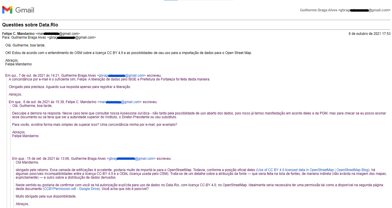
Capture of the e-mail message issued by Instituto Pereira Passos (IPP, an agency of the City Hall of Rio de Janeiro), which authorizes the use of data from the Data.Rio platform in OpenStreetMap.
Transcript of the message:
October 8, 2021 5:53 PM
Hello Guilherme, good afternoon,
OK! I agree with OSM's understanding of the CC BY 4.0 license and the possibilities of its use for importing data into Open Street Map.
Best regards, Felipe Mandarino
Felipe C. Mandarino Geographer - City Information Coordinator Instituto Pereira Passos, City Hall of Rio de Janeiro
10/07/2021 14:21 — Guilherme Braga Alves wrote:
The agreement by email is enough, Felipe. The release of data by the IBGE and the Municipality of Fortaleza was done in this way.
Thanks for your promptness. I await your reply just to register the release.
Best regards,
10/06/2021 15:39 — Felipe C. Mandarino wrote: Hello Guilherme, good afternoon,
Sorry for the delay in replying. In this case, I will have to consult our Legal Counsel - not so much for the possibility of open use of the data, as we already have an agreement between them and Municipal Attorney's Office, but to check if I can sign this document or if I would have to be the higher authority of the Institute , the Chief Executive Officer or his substitute.
For you, would there be a simpler way to overcome this? An e-mail agreement from me, for example?
Best regards, Felipe Mandarin
15/09/2021 13:06 — Guilherme Braga Alves wrote:
Hello Mandarino,
thanks for the feedback. This building layer is great, I would love to import it into OpenStreetMap. However, as per their official position (Use of CC BY 4.0 licensed data in OpenStreetMap | OpenStreetMap Blog), there are some possible incompatibilities between CC-BY 4.0 license and ODbL (license used by OSM). There is a detail about the attribution of the source — which would be done in the list of sources, indirectly (not shown in the image of the maps, explicitly) — and another one about the distribution of derived data.
In this sense, I would like to confirm with you if there is explicit authorization to use data in Data.Rio, with CC-BY 4.0 license, in OpenStreetMap. Ideally you would need a permission such as the one available on the second page of this document (CCBYPermission.odt - Google Drive). Do you think this is possible?
Thank you very much for your availability.
Best regards,
Português:
Captura da mensagem de e-mail emitida pelo Instituto Pereira Passos (IPP, órgão da Prefeitura da Cidade do Rio de Janeiro), onde se autoriza o uso dos dados da plataforma Data.Rio no OpenStreetMap.
Transcrição da mensagem:
8 de outubro de 2021 17:53
Olá, Guilherme, boa tarde,
OK! Estou de acordo com o entendimento do OSM sobre a licença CC BY 4.0 e as possibilidades de seu uso para a importação de dados para o Open Street Map.
Abraços, Felipe Mandarino
Felipe C. Mandarino Geógrafo - Coordenador de Informações da Cidade Instituto Pereira Passos, Prefeitura do Rio de Janeiro
07/10/2021 14:21 — Guilherme Braga Alves escreveu:
A concordância por e-mail é o suficiente sim, Felipe. A liberação de dados pelo IBGE e Prefeitura de Fortaleza foi feita desta maneira.
Obrigado pela presteza. Aguardo sua resposta apenas para registrar a liberação.
Abraços,
06/10/2021 15:39 — Felipe C. Mandarino escreveu: Olá, Guilherme, boa tarde,
Desculpe a demora na resposta. Nesse caso terei que consultar nossa Assessoria Jurídica - não tanto pela possibilidade de uso aberto dos dados, pois nisso já temos manifestação em acordo deles e da PGM, mas para checar se eu posso assinar esse documento ou se teria que ser a autoridade superior do Instituto, o Diretor-Presidente ou seu substituto.
Para vocês, existiria forma mais simples de superar isso? Uma concordância minha por e-mail, por exemplo?
Abraços, Felipe Mandarino
15/09/2021 13:06 — Guilherme Braga Alves escreveu:
Olá Mandarino,
obrigado pelo retorno. Essa camada de edificações é excelente, gostaria muito de importá-la para o OpenStreetMap. Todavia, conforme a posição oficial deles (Use of CC BY 4.0 licensed data in OpenStreetMap | OpenStreetMap Blog), há algumas possíveis incompatibilidades entre a licença CC-BY 4.0 e a ODbL (licença usada pelo OSM). Trata-se de um detalhe sobre a atribuição da fonte — que seria feita na lista de fontes, de maneira indireta (não exibida na imagem dos mapas, explicitamente) — e outro sobre a distribuição de dados derivados.
Neste sentido eu gostaria de confirmar com você se há autorização explícita para uso de dados no Data.Rio, com licença CC-BY 4.0, no OpenStreetMap. Idealmente seria necessário ter uma permissão tal como a disponível na segunda página deste documento (CCBYPermission.odt - Google Drive). Você acha que isto é possível?
Muito obrigado pela sua disponibilidade.
Abraços,
Licensing
![]()
Files without licences marked with this template are listed in Category:Media without a license or one of its subcategories. If the file is without a known open licence: ask its uploader to clarify situation or find a replacement and mark this file with {{Superseded by Commons}} and replace its uses.
If uploader was notified this month: use {{No licence|subcategory=uploader notified 2024, April}} - to put media into Category:Media without a license - uploader notified 2024, April and mark image as one where uploader was notified.
File history
Click on a date/time to view the file as it appeared at that time.
| Date/Time | Thumbnail | Dimensions | User | Comment | |
|---|---|---|---|---|---|
| current | 14:00, 9 October 2021 | | 1,347 × 716 (65 KB) | Guilherme B Alves (talk | contribs) | == English: == Capture of the e-mail message issued by Instituto Pereira Passos (IPP, an agency of the City Hall of Rio de Janeiro), which authorizes the use of data from the Data.Rio platform in OpenStreetMap. Transcript of the message: October 8, 2021 5:53 PM Hello Guilherme, good afternoon, OK! I agree with OSM's understanding of the CC BY 4.0 license and the possibilities of its use for importing data into Open Street Map. Best regards, Felipe Mandarino Felipe C. Mandarino Geographe... |
You cannot overwrite this file.
File usage
The following page uses this file: