File:Br-classificacao-santo-angelo-rs-plano-diretor.jpg
Jump to navigation
Jump to search

Size of this preview: 652 × 599 pixels. Other resolutions: 261 × 240 pixels | 522 × 480 pixels | 789 × 725 pixels.
Original file (789 × 725 pixels, file size: 95 KB, MIME type: image/jpeg)
Summary
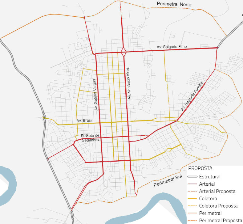
Classificação oficial segundo o plano de mobilidade, publicada em 15 de dezembro de 2016.
Disponível oficialmente no blog do núcleo técnico do Escritório da Cidade em PlanMob > Anexo 1 - Hierarquia Viária, em:
- Anexo 1.1: vias estruturais (VE)
- Anexo 1.2: vias perimetrais urbanas (VPU)
- Anexo 1.3: vias arteriais (VA)
- Anexo 1.4: vias coletoras (VC)
Licensing
![]()
This file has been released into the public domain by the copyright holder, its copyright has expired, or it is ineligible for copyright. This applies worldwide.
Please, please use more specific template such as {{PD-self}} / {{PD-creator}} / {{PD-shape}} / {{PD-USGov}} / {{PD-old}} / {{PD-RU-exempt}} ... This template is not making clear why this work is in the public domain.
Please, please use more specific template such as {{PD-self}} / {{PD-creator}} / {{PD-shape}} / {{PD-USGov}} / {{PD-old}} / {{PD-RU-exempt}} ... This template is not making clear why this work is in the public domain.
File history
Click on a date/time to view the file as it appeared at that time.
| Date/Time | Thumbnail | Dimensions | User | Comment | |
|---|---|---|---|---|---|
| current | 02:13, 4 January 2021 | | 789 × 725 (95 KB) | Ftrebien (talk | contribs) | Classificação oficial segundo o plano de mobilidade, publicada em 15 de dezembro de 2016. Disponível oficialmente no [http://ecidadesa.blogspot.com/ blog do núcleo técnico do Escritório da Cidade] em [http://ecidadesa.blogspot.com/p/plano.html PlanMob] > [https://drive.google.com/open?id=0Byef6VRPL3dZVmhWTEZLXzZLV1U Anexo 1 - Hierarquia Viária], em: * Anexo 1.1: vias estruturais (VE) * Anexo 1.2: vias perimetrais urbanas (VPU) * Anexo 1.3: vias arteriais (VA) * Anexo 1.4: vias coletoras (VC) |
You cannot overwrite this file.
File usage
The following page uses this file: