File:Correccion posicion y forma.jpg
Jump to navigation
Jump to search


Size of this preview: 800 × 408 pixels. Other resolutions: 320 × 163 pixels | 640 × 327 pixels | 1,024 × 523 pixels | 1,700 × 868 pixels.
Original file (1,700 × 868 pixels, file size: 358 KB, MIME type: image/jpeg)
Summary
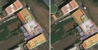
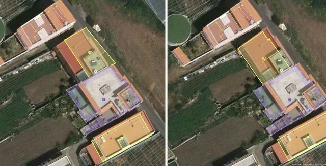
Correcciones geométricas en la importación de edificios de Catastro.
En el edificio identificado por el número 17 se ha realizado una corrección de la posición y de la forma. A la izquierda están los datos originales y a la derecha corregidos.
Licensing
![]()
This file has been released into the public domain by the copyright holder, its copyright has expired, or it is ineligible for copyright. This applies worldwide.
Please, please use more specific template such as {{PD-self}} / {{PD-creator}} / {{PD-shape}} / {{PD-USGov}} / {{PD-old}} / {{PD-RU-exempt}} ... This template is not making clear why this work is in the public domain.
Please, please use more specific template such as {{PD-self}} / {{PD-creator}} / {{PD-shape}} / {{PD-USGov}} / {{PD-old}} / {{PD-RU-exempt}} ... This template is not making clear why this work is in the public domain.
File history
Click on a date/time to view the file as it appeared at that time.
| Date/Time | Thumbnail | Dimensions | User | Comment | |
|---|---|---|---|---|---|
| current | 06:00, 6 December 2017 | | 1,700 × 868 (358 KB) | Javiersanp (talk | contribs) | Correcciones geométricas en la importación de edificios de Catastro. En el edificio identificado por el número 17 se ha realizado una corrección de la posición y de la forma. A la izquier... |
You cannot overwrite this file.
File usage
The following 2 pages use this file: