File:Denmark completeness.png
Denmark_completeness.png (439 × 539 pixels, file size: 278 KB, MIME type: image/png)
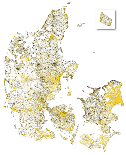
Visualization of the completeness of Denmark in January 2010. Image based on the per-pixel percentage of road names that appear in KMS adresses vs. OSM ways. Yellow areas such as København and Århus are (almost) complete. Black areas such as Randers and the coasts of north Sjælland are (almost) empty. White areas do not contain any KMS nodes.
![]()
![]()
The person who associated a work with this deed has dedicated the work to the public domain by waiving all of his or her rights to the work worldwide under copyright law, including all related and neighboring rights, to the extent allowed by law. You can copy, modify, distribute and perform the work, even for commercial purposes, all without asking permission.
File history
Click on a date/time to view the file as it appeared at that time.
| Date/Time | Thumbnail | Dimensions | User | Comment | |
|---|---|---|---|---|---|
| current | 15:28, 27 February 2010 | | 439 × 539 (278 KB) | Freek (talk | contribs) | Visualization of the completeness of Denmark in January 2010. Image based on the per-pixel percentage of road names that appear in KMS adresses vs. OSM ways. Yellow areas such as København and Århus are (almost) complete. Black areas such as Randers and |
You cannot overwrite this file.
File usage
The following 2 pages use this file: