File:Departements LambertCC9Zones.svg
Jump to navigation
Jump to search


Size of this PNG preview of this SVG file: 588 × 550 pixels. Other resolutions: 257 × 240 pixels | 513 × 480 pixels | 821 × 768 pixels | 1,095 × 1,024 pixels.
Original file (SVG file, nominally 588 × 550 pixels, file size: 359 KB)
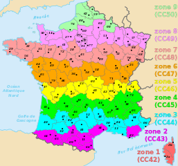
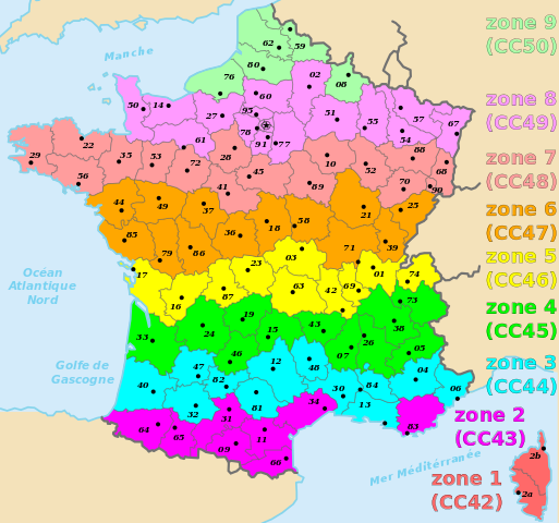
Picture of France divided in the 9 CC Lambert zones. This picture is based on this template. This drawing should stay in Public Domain or under the CC0 license.
Licensing
![]()
![]()
![]()
This work is licensed under the Creative Commons Attribution-ShareAlike 2.0 License.
Attribution not specified as a parameter! THIS LICENSE ALWAYS REQUIRES ATTRIBUTION! Use {{CC-BY-SA-2.0|Attribution, typically name of author}} See Template:CC-BY-SA-2.0 for full description how this template should be used.
Note, there is
There is also
Attribution not specified as a parameter! THIS LICENSE ALWAYS REQUIRES ATTRIBUTION! Use {{CC-BY-SA-2.0|Attribution, typically name of author}} See Template:CC-BY-SA-2.0 for full description how this template should be used.
Note, there is
{{CC-BY-SA-2.0 OpenStreetMap}} for files based on old OSM map data, before the license change made on 2012-09-12.There is also
{{OSM Carto screenshot||old_license}} for files based on old OSM map data, before the license change made on 2012-09-12, created using OSM Carto map style.
![]()
Contains map data © OpenStreetMap contributors, made available under the terms of the Creative Commons Attribution-ShareAlike 2.0 (CC-BY-SA-2.0).
File history
Click on a date/time to view the file as it appeared at that time.
| Date/Time | Thumbnail | Dimensions | User | Comment | |
|---|---|---|---|---|---|
| current | 11:36, 10 November 2009 | | 588 × 550 (359 KB) | Kevredon (talk | contribs) | Picture of France divided in the 9 Lambert zones. This picture is based on this [https://secure.wikimedia.org/wikipedia/commons/wiki/File:D%C3%A9partements_de_France.svg template]. This drawing should stay in Public Domain or under the [http://creativecom |
You cannot overwrite this file.
File usage
The following page uses this file: