File:Example2 london.png
Jump to navigation
Jump to search


Size of this preview: 422 × 600 pixels. Other resolutions: 169 × 240 pixels | 338 × 480 pixels | 698 × 992 pixels.
Original file (698 × 992 pixels, file size: 739 KB, MIME type: image/png)
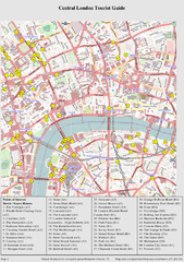
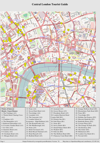
Example output from the townguide map generator.
This is a Featured image, which means that it has been identified as one of the best examples of OpenStreetMap mapping, or that it provides a useful illustration of the OpenStreetMap project. If you know another image of similar quality, you can nominate it on Featured image proposals.
Front-page image for week 16 of 2010 (19–25 Apr.).
- Image descriptions
- Deutsch : TownGuide erstellt PDF-Karten mit Straßen- und POI-Index.
- English : TownGuide will render PDF maps with street & POI indexes
- français : TownGuide effectue un rendu PDF de cartes avec index des rues et des POI.
- italiano : TownGuide genererà le mappe in formato PDF con gli indici delle strade e dei punti di interesse
- magyar : A TownGuide PDF térképeket renderel utcanév- és POI-jegyzékkel.
- polski : TownGuide renderuje mapy w PDF ze spisem ulic i ważnych miejsc.
- português : TownGuide renderiza mapas em PDF com índices de ruas e pontos de interesse.
- русский : Рендерер TownGuide создаёт карты в формате PDF с каталогом улиц и значимых мест (POI)
File history
Click on a date/time to view the file as it appeared at that time.
| Date/Time | Thumbnail | Dimensions | User | Comment | |
|---|---|---|---|---|---|
| current | 10:03, 14 April 2010 | | 698 × 992 (739 KB) | Bilbo (talk | contribs) | Example output from the townguide map generator. {{featured_date|2010|16}} |
| 22:00, 21 March 2010 | 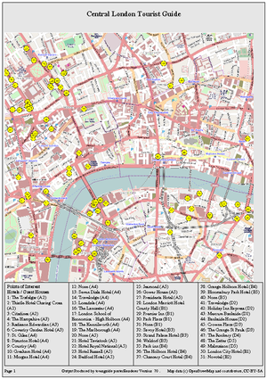 | 300 × 425 (563 KB) | Grahamjones (talk | contribs) | Example output from the townguide map generator. |
You cannot overwrite this file.