File:Example forest compartment.png
Jump to navigation
Jump to search


Size of this preview: 800 × 439 pixels. Other resolutions: 320 × 176 pixels | 640 × 351 pixels | 1,239 × 680 pixels.
Original file (1,239 × 680 pixels, file size: 223 KB, MIME type: image/png)
Summary
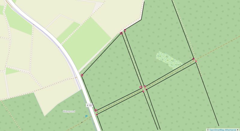
forest compartment in Germany location: https://www.openstreetmap.org/#map=17/50.56925/8.77079 Red circles = positions of markers showing compartment ref, name, operator Black lines = boundary=forest_compartment inferred from markers, tracks and cutlines
the wetland is part of the compartment
example does not include boundary=forest
Licensing
| Contains map data © OpenStreetMap contributors, made available under the terms of the Open Database License (ODbL).
The ODbL does not require any particular license for maps produced from ODbL data, produced maps may be subject also to other licences. |
File history
Click on a date/time to view the file as it appeared at that time.
| Date/Time | Thumbnail | Dimensions | User | Comment | |
|---|---|---|---|---|---|
| current | 13:54, 6 February 2022 | | 1,239 × 680 (223 KB) | Lkw (talk | contribs) | forest compartment in Germany location: https://www.openstreetmap.org/#map=17/50.56925/8.77079 Red circles = positions of markers showing compartment ref, name, operator Black lines = boundary=forest_compartment inferred from markers, tracks and cutlines example does not include boundary=forest |
You cannot overwrite this file.
File usage
There are no pages that use this file.