File:GOAT Poster StoM.pdf
Original file (4,966 × 7,020 pixels, file size: 2.6 MB, MIME type: application/pdf)
Summary
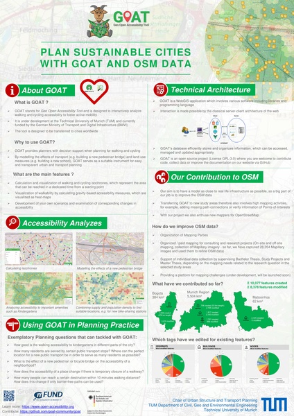
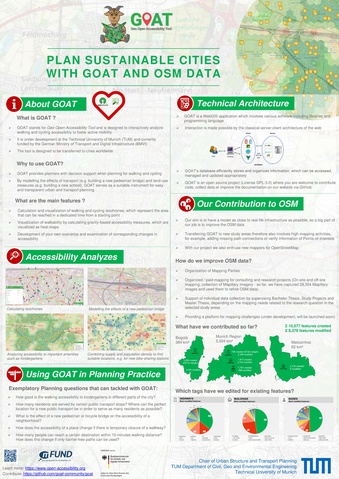
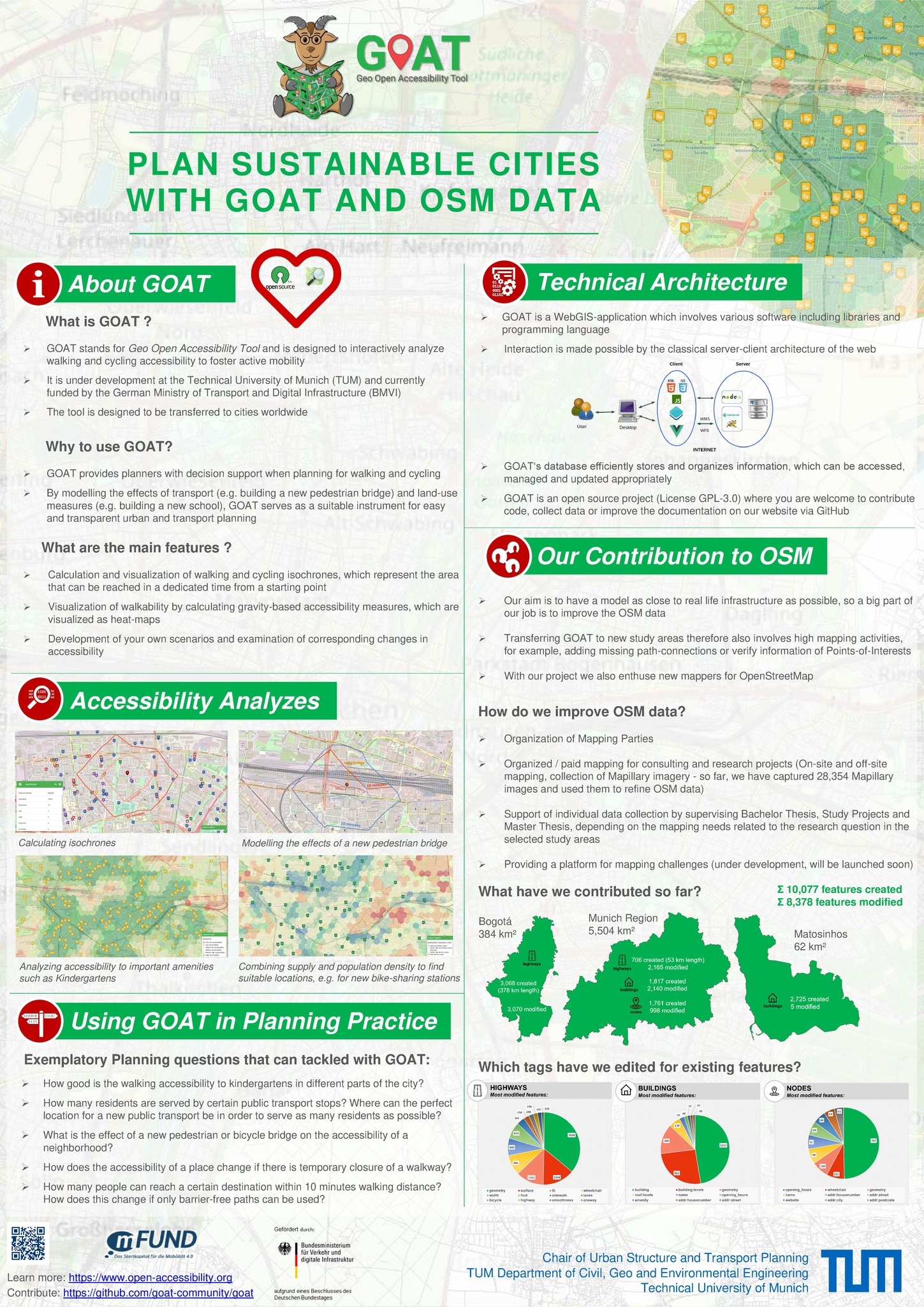
GOAT stands for Geo Open Accessibility Tool and is designed to interactively model walking and cycling accessibility. The role of active mobility in urban planning is becoming more and more important – GOAT aims to provide elaborated decision support for planners to objectively plan more sustainable cities. The tool is under development at the Technical University of Munich (https://www.bgu.tum.de/en/sv/research-group-accessibility-planning/) and is currently funded by the German Ministry of Transport and Digital Infrastructure.
GOAT serves as a suitable instrument for transport and urban planning in an easy and transparent way. The tool allows to calculate and visualize walking and cycling isochrones representing the area that can be reached in a dedicated time from one or several starting points. Furthermore, the walkability to certain destinations can be analyzed by calculating gravity-based accessibility measures, which are visualized as heat-maps. The development of own scenarios allows to analyze corresponding changes in accessibility and find suitable locations for new infrastructure. This can be for example the construction of a new bridge or a new school, which changes the accessibility in a certain area. Therewith, GOAT supports planners in decision-making processes for walking and cycling by modelling accessibility and the effects of transport and land-use measures.
GOAT can be used to answer planning questions about how good the walking accessibility to kindergartens is or how many residents are served by certain public transport stops. Best possible locations for new public transport can also be answered with GOAT or, for example, how a new pedestrian or bicycle bridge can affect the accessibility of a neighborhood. Furthermore, it can be examined how many people reach a destination within a walking distance of 10 minutes when only barrier-free paths are used.
Technically GOAT is a WebGIS-application and therefore uses a wide array of different open source libraries and programming languages. The architecture makes use of the classical server-client architecture of the web and the core of the analysis is done on a spatially enabled database. GOAT is an open source project (License GPL-3.0) and was built completely with open source code and software. In addition, GOAT build mainly on Open Data, especially on OpenStreetMap (OSM). We also actively improve OSM data by adding missing path connections or verifying information of Points-of-Interests and much more. By supervising Bachelor Thesis, Study Projects and Master Thesis we support the collection of OSM data depending on the mapping needs related to the research. We also contribute to OSM by organizing mapping parties and paid mapping for consulting and research projects. In total, we created 10,077 and modified 8,378 OSM features. You are highly welcome to visit our website, contribute code, collect data or improve the documentation via GitHub!
GOAT Website: https://www.open-accessibility.org/
GOAT Webtool: https://www.open-accessibility.org/versions
GOAT GitHub: https://github.com/goat-community
TUM Chair of Urban Structure and Transport Planning: https://www.bgu.tum.de/en/sv/homepage/
File history
Click on a date/time to view the file as it appeared at that time.
| Date/Time | Thumbnail | Dimensions | User | Comment | |
|---|---|---|---|---|---|
| current | 16:51, 30 June 2020 |  | 4,966 × 7,020 (2.6 MB) | UJehle (talk | contribs) | GOAT stands for Geo Open Accessibility Tool and is designed to interactively model walking and cycling accessibility. The role of active mobility in urban planning is becoming more and more important – GOAT aims to provide elaborated decision support for planners to objectively plan more sustainable cities. The tool is under development at the Technical University of Munich (https://www.bgu.tum.de/en/sv/research-group-accessibility-planning/) and is currently funded by the German Ministry of... |
You cannot overwrite this file.
File usage
There are no pages that use this file.