File:Haiti eq2021 hot.png
Jump to navigation
Jump to search


Size of this preview: 800 × 581 pixels. Other resolutions: 320 × 232 pixels | 640 × 464 pixels | 875 × 635 pixels.
Original file (875 × 635 pixels, file size: 77 KB, MIME type: image/png)
Summary
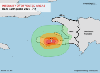
A magnitude 7.2 earthquake has struck the island nation of Haiti. This image shows the shakemap using data from the Joint Research Center of the European Commission (EC-JRC).
Licensing
![]()
This file has been released into the public domain by the copyright holder, its copyright has expired, or it is ineligible for copyright. This applies worldwide.
Please, please use more specific template such as {{PD-self}} / {{PD-creator}} / {{PD-shape}} / {{PD-USGov}} / {{PD-old}} / {{PD-RU-exempt}} ... This template is not making clear why this work is in the public domain.
Please, please use more specific template such as {{PD-self}} / {{PD-creator}} / {{PD-shape}} / {{PD-USGov}} / {{PD-old}} / {{PD-RU-exempt}} ... This template is not making clear why this work is in the public domain.
File history
Click on a date/time to view the file as it appeared at that time.
| Date/Time | Thumbnail | Dimensions | User | Comment | |
|---|---|---|---|---|---|
| current | 21:51, 16 August 2021 | | 875 × 635 (77 KB) | Claurt07 (talk | contribs) | A magnitude 7.2 earthquake has struck the island nation of Haiti. This image shows the shakemap using data from the Joint Research Center of the European Commission (EC-JRC). |
You cannot overwrite this file.
File usage
The following page uses this file: