File:Mirnyal comparison.png
Jump to navigation
Jump to search

No higher resolution available.
Mirnyal_comparison.png (800 × 308 pixels, file size: 198 KB, MIME type: image/png)
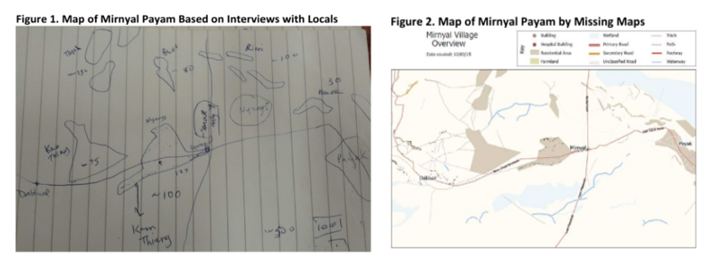
Comparing Missing Maps map of Mirnyal with map based on interviews with locals. Photo taken by, and digital map created by, Pete Masters and made available under the Creative Commons Attribution 2.0 License.
![]()
![]()
This work is licensed under the Creative Commons Attribution 2.0 License.
Attribution not specified as a parameter! THIS LICENSE ALWAYS REQUIRES ATTRIBUTION! Use {{CC-BY-2.0|Attribution, typically name of author}} See Template:CC-BY-2.0 for full description how this template should be used.
Attribution not specified as a parameter! THIS LICENSE ALWAYS REQUIRES ATTRIBUTION! Use {{CC-BY-2.0|Attribution, typically name of author}} See Template:CC-BY-2.0 for full description how this template should be used.
File history
Click on a date/time to view the file as it appeared at that time.
| Date/Time | Thumbnail | Dimensions | User | Comment | |
|---|---|---|---|---|---|
| current | 17:12, 5 December 2015 | 800 × 308 (198 KB) | Pedrito1414 (talk | contribs) | Comparing Missing Maps map of Mirnyal with map based on interviews with locals |
You cannot overwrite this file.
File usage
There are no pages that use this file.