File:Pedestrian area routing-ES.svg
Jump to navigation
Jump to search

Size of this PNG preview of this SVG file: 800 × 267 pixels. Other resolutions: 320 × 107 pixels | 640 × 213 pixels | 1,024 × 341 pixels | 1,280 × 427 pixels | 810 × 270 pixels.
Original file (SVG file, nominally 810 × 270 pixels, file size: 41 KB)
Summary
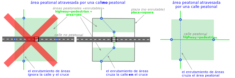
Mapping a pedestrian area crossed by a street.
Other versions
Version in English
Licensing
![]()
![]()
![]()
This work is licensed under the Creative Commons Attribution-ShareAlike 4.0 License.
Attribution: Carto'Cité
Attribution: Carto'Cité
File history
Click on a date/time to view the file as it appeared at that time.
| Date/Time | Thumbnail | Dimensions | User | Comment | |
|---|---|---|---|---|---|
| current | 14:27, 7 September 2019 | 810 × 270 (41 KB) | Dcapillae (talk | contribs) | Mapping a pedestrian area crossed by a street. == Other versions == <gallery> File:Pedestrian_area_routing-EN.svg|Version in English </gallery> |
You cannot overwrite this file.
File usage
The following 2 pages use this file: