File:Welsh heaths alluvial p1 osm.png
Jump to navigation
Jump to search


Size of this preview: 600 × 600 pixels. Other resolutions: 240 × 240 pixels | 480 × 480 pixels.
Original file (800 × 800 pixels, file size: 37 KB, MIME type: image/png)
Summary
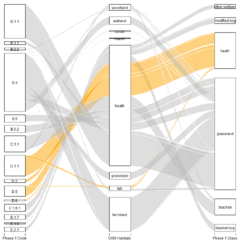
Correspondences between Phase 1 Habitat codes & classes with grouped OSM natural and landuse habitats.
Phase 1 data from Natural Resources Wales: Crown Copyright & database right. Released under OGL.
Licensing
| Contains map data © OpenStreetMap contributors, made available under the terms of the Open Database License (ODbL).
The ODbL does not require any particular license for maps produced from ODbL data, produced maps may be subject also to other licences. |
File history
Click on a date/time to view the file as it appeared at that time.
| Date/Time | Thumbnail | Dimensions | User | Comment | |
|---|---|---|---|---|---|
| current | 13:37, 26 October 2021 | | 800 × 800 (37 KB) | SK53 (talk | contribs) | Correspondences between Phase 1 Habitat codes & classes with grouped OSM natural and landuse habitats. Phase 1 data from Natural Resources Wales: Crown Copyright & database right. Released under OGL. |
You cannot overwrite this file.
File usage
There are no pages that use this file.