OpenSeaMap and Garmin nautical chart plotter
OpenSeaMap worked for many years on chartplotters and most handhelds from Garmin.
A new management had decided in 2017 to exclude OpenSeaMap on chartplotters. Eine neue Firmware sorgt dafür.
But there are hints that you can downgrade some plotters to an old firmware version.
Download
Maps of any region are created and made available for download within a few minutes by the following service:
Use the following link to download newest generation OpenSeaMap of Europe. It works on chartplotters even with recent firmware:
https://drive.google.com/drive/folders/0Bz9KchYfWW3reE50SG1OYkZrTjQ?usp=sharing
Forum: http://forum.openseamap.org/viewtopic.php?id=1833 and http://forum.openseamap.org/viewtopic.php?id=2143
Coverage
Coverage is worldwide.
Characteristics of the map
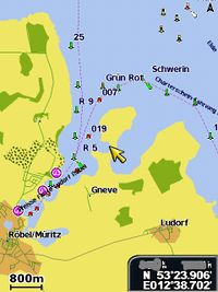
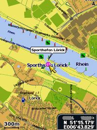
When zooming in, you can see buildings.
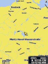
When zooming out, the streets disappear and you will see an overview map of rivers and water surfaces.
Tips & Tricks
- Older devices may only support maps up to 2 GB.
Device list
OpenSeaMap works on the following Garmin devices: ![]() = tested successfully
= tested successfully
All these devices should work for OpenSeaMap, also all the hand-helds and chart plotters in this list:
| ok | Type | Comments |
|---|---|---|
| Echomap 50 dv | Plotter with integrated Fishfinder | |
| Echomap 50 s | Plotter with integrated Fishfinder | |
| GPSmap 7015 | ||
| GPSmap 7012 | ||
| GPSmap 6012 | ||
| GPSmap 6008 | ||
| GPSmap 6012 | ||
| GPSmap 6008 | ||
| GPSmap 5015 | ||
| GPSmap 5012 | ||
| GPSmap 5008 | ||
| GPSmap 4012 | ||
| GPSmap 4010 | ||
| GPSmap 4008 | ||
| GPSmap 720 / 720s | Touch screen | |
| GPSmap 620 | Portable two-in-one touch screen device for street and marine applications | |
| GPSmap 531 / 531s | ||
| GPSmap 527 | ||
| GPSmap 526 / 526s | ||
| GPSmap 521 / 521s | ||
| GPSmap 421 / 421s | ||
| GPSmap 172C | No longer available | |
| GPSmap 60 cx | Outdoor | |
| GPSmap 60 CSx | Outdoor | |
| GPSmap 62 s | Outdoor | |
| GPSmap 62 sc | Outdoor | |
| GPSmap 62 st | Outdoor | |
| GPSmap 62 stc | Outdoor | |
| GPSmap 64 s | Outdoor | |
| Colorado | No longer available | |
| Dacota 20 | Outdoor | |
| eTrex 10 | Outdoor, by Mapsource + Multistorage (only 12MB) | |
| eTrex 20 | Outdoor | |
| eTrex 30 | Outdoor | |
| eTrex Legend HCx | Outdoor | |
| eTrex Venture HC | Outdoor, by Mapsource | |
| eTrex Vista HCx | Outdoor | |
| Montana 600 | Outdoor | |
| Montana 650 | Outdoor | |
| Montana 650 t | Outdoor | |
| Oregon 550 | Outdoor | |
| Oregon 450 | Outdoor with marine mode |
Technical background
Over time, the various Garmin devices for car, outdoor and marine applications have evolved in different directions.
New maps are only compatible with the device for the respective target group. NT maps with lane assist guides and traffic information only work on Garmin nüvi devices, whereas the very detailed and colourful topographic maps are meant for use in outdoor devices. However, Bluechart G2 Vision only works in combination with marine devices. All sea maps, either traditional Bluechart, G2 or G2 Vision, work without TYPE files, as these do not display particularly detailed or multi-coloured images on shore. The Bluechart version does not offer green meadows, brown fields or even tree symbols in a forest. However, outdoor devices were designed to be used in a car or on a boat as well. For this reason, a partial support for NT and Bluechart (G2) was implemented. Unfortunately, they did not implement lane assist guides or Bluechart Vision.
So far, Garmin marine devices do not support TYPE files (for freely definable symbols, colours and textures). In order to display polygons, only a few clearly defined colours and textures are available. Without TYPE files, however, the priority of polygons cannot be defined. Maps that are displayed perfectly on Garmin outdoor or travel devices generally do have the same quality on marine devices and are therefore unusable.
Garmin has built in a locking mechanism in newer marine devices to prevent older Bluecharts (without G2) from being used (Message: "Karte nicht kompatibel" [Map is not compatible]). This lock also takes effect when OSM cards are involved.
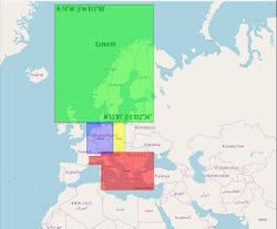
Thus, a special OpenSeaMap chart was developed for owners of Garmin marine devices. It is particularly designed to adapt to the options of marine devices, which are rather limited compared to those of outdoor devices. This chart also works on outdoor devices with marine mode (e. g. Oregon) without any restrictions. It should also work for older marine devices. However, you should not download the entire map of Europa to less powerful devices in one go, but choose MapSource sections instead. Otherwise the image buildup will be very slow and there can be gaps in the map if the working memory is too small.
On devices that are exclusively used in cars (nüvi series) the map will probably not work without restrictions. Devices for aviation have not been tested so far. px


