GeoSDS: Mapping of Ambulance Emergency Response Time in DKI Jakarta
The population growth in Jakarta, which serves as the heartbeat of Indonesia, should be accompanied by adequate infrastructure development to support the livelihood of the community. Especially when it comes to health facilities such as ambulances, which are crucial as the first responders during critical moments for patients. However, the increasing population density and worsening traffic conditions in Jakarta make it difficult for ambulance fleets to reach all areas in Jakarta in a timely manner, as recommended by the Ministry of Health (Kemenkes), which is within 15 minutes [1].
This situation is further exacerbated by the lack of complete maps showing the distribution of ambulances in Jakarta. At least, comprehensive information on ambulance availability is not easily accessible to the general public. It is not surprising that according to research by SN Brice [2], out of 1964 surveyed patients in Jakarta, the majority of them preferred to use their own motorcycle or car to transport patients to the hospital. Ambulances were only used by 9.3% of all surveyed patients, and 38% of these patients were not aware of the availability of ambulances for their use. Reluctance to use ambulances may be due to the common assumption among the public that ambulance services are costly compared to other modes of transportation.
Therefore, the availability of this information is not only important for the public, but also crucial for stakeholders in Jakarta to make informed decisions regarding the placement of ambulances. Hence, the project proposed by GeoSDS is the "Emergency Response Time Mapping of Ambulances in DKI Jakarta".
The mapping activity "Emergency Ambulance Response Time Mapping in DKI Jakarta" aims to realize sustainable cities and communities and to help improve public health information for the general public. The availability of ambulance distribution maps accessible to the general public is expected to be a form of open government that can involve the community in solving public problems. Furthermore, the emergency ambulance response time map in DKI Jakarta is expected to provide information to the government and social institutions about the sufficiency of ambulance availability in DKI Jakarta, and ultimately throughout Indonesia.
Solution
The lack of comprehensive information about ambulances in Jakarta is evident from the findings of the SN Brice study [2] conducted in 2022. The study showed that more than 90% of surveyed patients did not use ambulances for urgent health needs for themselves and their families. Furthermore, the public perceives that the cost of using an ambulance is relatively high compared to other modes of transportation, including using their own vehicle. Nearly half of the surveyed patients were also unaware that there are ambulances available to help them during critical times in transporting patients to hospitals.
Addressing this issue, it is necessary to conduct mapping of ambulances themselves. However, it is almost impossible to map ambulances if the information about them has not been collected. Therefore, one of the main goals of this project is to integrate and publish ambulance data collected by the government and non-governmental organizations. In this opportunity, GeoSDS also aims to educate the members of the community, specifically the academics at Bakrie University, and the general public in South Jakarta about the use of OpenStreetMap and how to conduct mapping activities.
Implementation
The ongoing activities have encountered several challenges, but have been successful in addressing the initial questions of ambulance availability in Jakarta. The educational activities on OpenStreetMap and how to conduct mapping have been smoothly carried out on January 14, 2023. The next activity was a Mapathon targeted only at academics from Bakrie University. However, the response to this activity was relatively low, possibly due to the campus activities being suspended during the semester break.
The next step was to visit partners from government and non-governmental organizations to obtain ambulance information from their databases. Initially, these partners responded positively, but difficulties arose during the discussion on data sharing. This could be due to the sensitive nature of the data and the bureaucratic challenges in accessing and sharing such information. Lastly, the data obtained will be compiled with population density and road conditions to generate the final analysis, which will be a map of ambulance response time in all areas of DKI Jakarta.
Activity
Mapathon
The Mapathon activity, which took place from January 15 to March 17, 2023, invited several individuals from Bakrie University to contribute to ambulance mapping. The aim of this activity was to introduce the concept and power of spatial data to academics in the Bakrie University community, and how the end results can contribute to the society. The Mapathon activity, which offered attractive prizes, was initially introduced at the end of a workshop on January 14, 2023. Subsequently, the Mapathon was also promoted through social media, and through bulletin boards at Bakrie University.
Overall, the Mapathon activity can be considered successful as it received participation from Bakrie University academics, which then sparked discussions on spatial data and the positive impacts that can be achieved through its use. At the end of the activity, prizes were awarded to the first, second, and third place winners. The first place was won by Team Raden Bambang Syumanjaya and Ni Kadek Sri Manik, the second place was won by Team Zakiul Fahmi Jailani and Rizky Maudy Aryanti, and the third place was won by Team Dita Nurmadewi and Rohmad Fitriyan.
Data Compilation and Analysis
The next step is to gather supporting data for the final analysis and compile it. The first data to be compiled is population density data, obtained from Data.Jakarta.go.id. The population density data is compiled with the administrative boundaries data of Jakarta. In addition, another data that has been obtained is road network data from OpenStreetMap Indonesia. This data has also been adjusted to match the administrative boundaries of Jakarta.
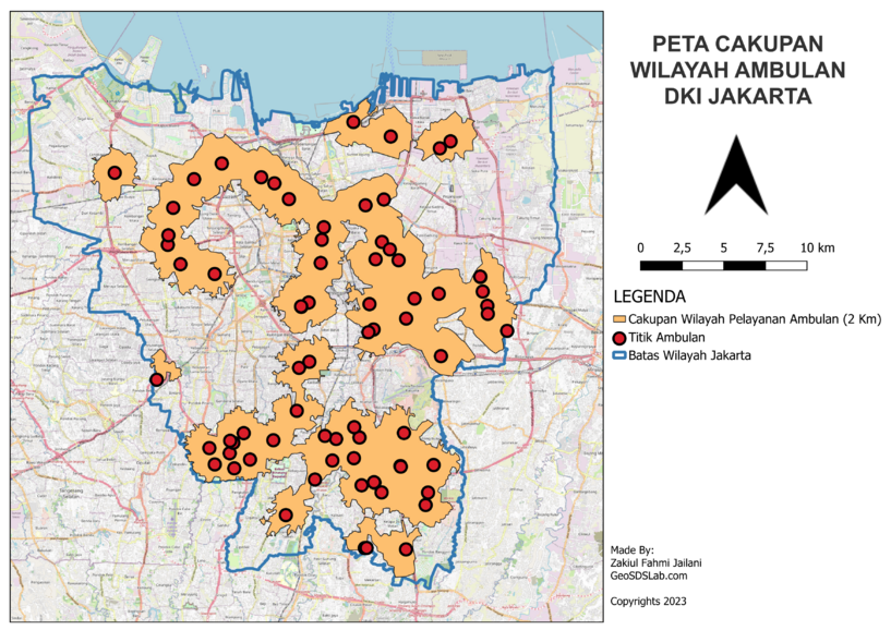
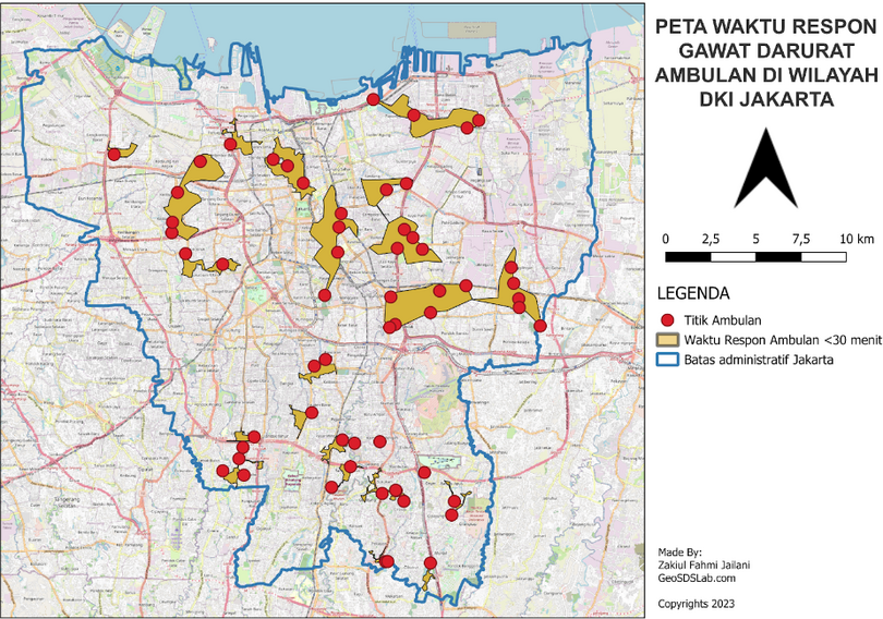
Next, the next step is to perform spatial analysis. There are three spatial analyses conducted. The first one is the spatial analysis of coverage areas. In this analysis, each ambulance point is analyzed spatially using the service area tool in QGIS with a parameter of 2 kilometers distance to the road network data. The result is a map of Ambulance Service Coverage Areas. The second analysis is the ambulance response time analysis. In this analysis, the service area tool in QGIS is also used, but the parameter used is the speed of ambulance points through the road network data for 30 minutes. This 30-minute parameter is different from the recommendation of the Ministry of Health mentioned in the Background section, which is 15 minutes. The 30-minute parameter was chosen based on input from partners who stated that 30 minutes is more realistic and has been the actual minimum response time in the field.
The last analysis is the demographic analysis of population density, which will result in a map of population coverage that can be served by ambulances. This analysis is done using the clip tool in QGIS. The clip boundary data used is the polygon from the analysis result of the ambulance coverage areas map, while the input layer is the population density data. The final result will provide the number of population density points that fall within the polygon of the ambulance coverage areas map.
WebGIS Development
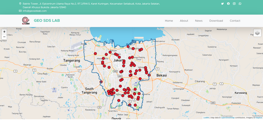
The creation of a WebGIS that displays ambulance points in Jakarta and compiled on the website https://geosdslab.com/ is one of the final stages of this research. This stage begins with hiring a freelance WebGIS developer recruited through the fastwork.com website/application. Then, several online meetings are held to discuss the features and results that will be displayed through this WebGIS.
The first and most important visualization of this WebGIS is the layer displaying the distribution of ambulance points throughout Jakarta. The data displayed includes the ambulance points collected through Mapathon, as well as data provided by partners. Subsequently, users can choose to display other layers, including population density data, ambulance service area coverage data, ambulance response time data, and ambulance-to-population ratio data.
In addition, this WebGIS also provides a separate download page for anyone who wants to download the compiled and analyzed ambulance data.
Dissemination
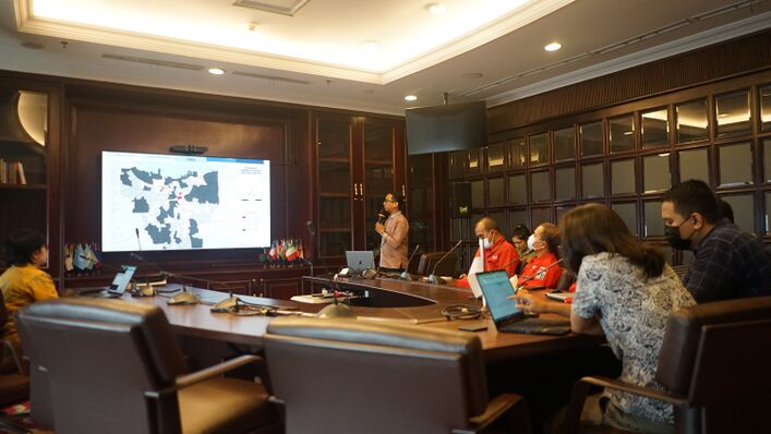
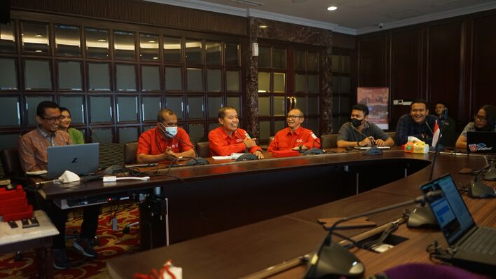
This activity is carried out to present the final results of the ambulance mapping project to all partners, as well as to deliver award plaques to them. In addition, the event is covered by the media. The event will be held on April 5, 2023, at the Diplomatic Room of Bakrie University, 40th Floor Bakrie Tower. The aim of this event is to present the research findings. During the event, a demonstration of the website www.geosdslab.com will be conducted, showcasing the features of the website that can be used by each partner. The event will also include the presentation of award plaques to partners who have contributed their data to GeoSDS.
Finally, this event aims to gather all partners. Based on discussions with several partners, it has been mentioned that they hope for an initiative to integrate all ambulances in Jakarta, so that in case of massive emergencies such as natural disasters, all ambulances can be coordinated under one command. Therefore, this event aims to bring together all partners and discuss how to realize the initiative to integrate the ambulance systems throughout DKI Jakarta. The website www.geosdslab.com is one of the smallest initial initiatives that can be done, and the policymakers of each partner will be responsible for further actions.
Final Output and Outcome
For the Community:
- Spatial Data and OpenStreetMap Workshop
- Establishment of a new geospatial data science community among the academicians of Bakrie University
- Emergence of several new mappers
- Formation of new collaborations between GeoSDS and relevant government agencies and non-governmental organizations
| Indicator | Contribution after March 3 2023 | Notes |
| Result | ||
| Outputs | ||
| #number of mapped ambulance | 71 ambulance | Information about the geographic location of ambulance stops was identified through field surveys, such as latitude and longitude coordinates.
|
| #WebGIS | Open Source WebGIS | |
| New OSM Mapper | 6 | https://www.openstreetmap.org/user/zakiul_fahmi_jailani
https://www.openstreetmap.org/user/Maudy%20Aryanti https://www.openstreetmap.org/user/rfriyan https://www.openstreetmap.org/user/Raden%20Bambang%20Syumanjaya https://www.openstreetmap.org/user/DNurma https://www.openstreetmap.org/user/Ni%20Kadek |
Challenges
Preparation and Planning: One challenge is obtaining data from relevant partners. Additionally, there are constraints with impractical permits from government agencies such as AGD DinKes (Health Office) for data provision.
Data Processing and Presentation: Insufficient additional data to be compiled with the main ambulance data is a challenge. For example, population density data is only available for the year 2020 (during the pandemic). Similarly, road condition data is limited to road networks, with no free access to traffic data. Due to this data insufficiency, the final analysis of the map is not optimal. Therefore, additional time is needed to obtain additional ambulance data, especially from the Emergency Ambulance of the Health Office.
Another challenge is that the team has not yet obtained ambulance data from the Health Office. The hope is to obtain this data in the remaining time of March. Other challenges include the completion of the new WebGIS by early April and the time-consuming mapping analysis.
Sustainability
From the activities carried out, GeoSDS is still very enthusiastic and optimistic about achieving the desired results. Despite many obstacles related to data collection, the audience conducted with government institutions and community organizations has revealed that spatial data management at the institutional level is still insufficient. This can be seen as a concerning situation, but on the other hand, it also indicates a great opportunity to conduct various spatial analyses to help the government solve problems, and ultimately improve people's lives through the spirit of open government and open data.
In addition, workshops and seminars conducted to introduce spatial data and OpenStreetMap have shown tremendous enthusiasm from participants. It's as if they just realized that there are tools and data that can be obtained for free but have tremendous potential for use. This shows that workshops and seminars related to OpenStreetMap can also be offered to relevant agencies or community organizations that want to acquire such knowledge. This can help them familiarize themselves with OSM in particular, and use spatial data as a basis for their strategic decisions in general.
Furthermore, GeoSDS has started building a WebGIS that will not only serve as an information access platform for the general public, but also allow anyone to download the spatial data provided on the WebGIS. These features have been well-received, for example by AGD DinKes, and they personally requested the addition of several spatial analyses that are relevant to what they gather in the field. They also requested that the WebGIS be linked to their own website, and they expressed interest in further collaborations related to ambulance availability campaigns for the public.
The expected impacts that WebGIS can provide to the public and stakeholders are increased awareness of ambulance adequacy in Jakarta. The information conveyed to the general public is also expected to be about the proper placement of new ambulances if there are proposals for adding new ambulances in Jakarta areas. Moreover, this WebGIS also contains information on ambulance points that can be accessed by the public, where each ambulance point contains information on the ambulance name (operator) and contact number.
On the other hand, WebGIS can also raise awareness among stakeholders about the adequacy of ambulance availability in their jurisdiction. This will enable them to propose additional ambulances and, using this WebGIS, they will be able to easily place new ambulances in areas that still lack them.
Contact
References
[1] Awad, A., Ali, H., Abujayyab, S. K., Karas, I. R., & Sumunar, D. R. S. (2020). Measuring the spatial readiness of ambulance facilities for natural disasters using GIS networks analysis. The International Archives of Photogrammetry, Remote Sensing and Spatial Information Sciences, 44, 81-84.
[2] Brice, S. N., Boutilier, J. J., Gartner, D., Harper, P., Knight, V., Lloyd, J., ... & Tuson, M. (2022). Emergency services utilization in Jakarta (Indonesia): a cross-sectional study of patients attending hospital emergency departments. BMC health services research, 22(1), 1-10.
