Humanitarian OSM Team/Open Mapping Hub - Latin America and The Caribbean/Activations/2024 Quintana Roo Hurricanes Response
| Background | |||||||||||||
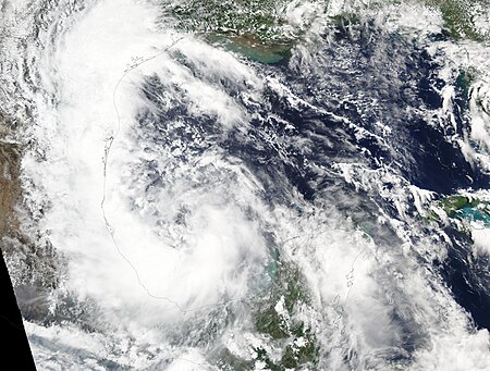
Context of the ActivationAs of June 2024, both Hurricane Alberto and Hurricane Beryl are significantly impacting the Yucatán Peninsula, particularly in Quintana Roo. These hurricanes have prompted urgent alerts throughout the region, leading authorities to activate emergency shelters. The combined effects of these hurricanes have caused substantial disruptions. Heavy rains and strong winds have resulted in flooding, causing widespread chaos and significant challenges. In response, as part of the Mapping for Climate Ready Cities Program, the Open Mapping Hub in Latin America and the Caribbean Hub (Humanitarian Team of OpenStreetMap) and CoMapper, in collaboration with the Quintana Roo Government, are calling on mappers with intermediate experience to participate in the emergency mapping activation on OpenStreetMap (OSM) in Quintana Roo. The primary objective will be to map temporary shelters following the passage of Hurricanes Alberto and Beryl. | |||||||||||||
Contacts
Hashtag
All contributions through HOT's Tasking Manager are tracked with a unique change set comment tag: #2024_mxqroo_shelters
Timeline
- Start: July 1, 2024
- End: To be defined
Remote Mapping Coordination
- Source data for task location in populated places: TBC
- List of active projects in the Tasking Manager: TBC
- Leaderboard for tracking general editing statistics: TBC
Dashboard to Track General Editing Statistics
Map and Data Services
Exporting OpenStreetMap data
About This Disaster Activation
About HOT
To learn more about the Humanitarian OpenStreetMap Team (HOT), explore more of our wiki-pages (root: HOT) or our website hotosm.org. HOT is a global community, mostly of volunteers, and it is a US registered nonprofit able to contract with organizations (email info at hotosm.org to contact our staff), we are also a 501(c)(3) charitable organization.
History of this Activation
Implementing Partner
July 1, 2024 - In response to Hurricanes Alberto and Beryl, as part of the Mapping for Climate Ready Cities Program, the Latin America and the Caribbean Hub from the Humanitarian Team of OpenStreetMap and CoMapper, in collaboration with the Quintana Roo Government, are calling on mappers with intermediate experience to participate in the emergency mapping activation on OpenStreetMap (OSM) in Quintana Roo. The primary objective will be to map temporary shelters.
Coordination Lead(s)
- Céline Jacquin (HOT Tasking Manager support)
Data Quality
Validation
Validation permissions for Tasking Manager projects are restricted to particular Tasking Manager Teams / users to ensure high quality validation:
- HOT Global Validators
- Validator Trainees
- MSF Validators
- Data Quality Interns
- Data Quality Interns 2022
OSMCha
A specific OSMCha filter can be used to detect data quality issues across a wider area.
Overpass Turbo
A specific Overpass Turbo query can be used to check the data quality regularly. Open it in JOSM and run validation (Shift+V).
For Mappers
How You Can Contribute
Learn to Map
- Most of our volunteer needs are for remote OSM contributors, visit LearnOSM.org and MapRoulette to get started.
Mapping Priority
- Please choose from highest priority first,
- Experienced mappers are also asked to participate in validating completed tasks. Information on validating can be found here:
| MapRoulette Projects | ||||
| Project | Priority | Name | Task Mapping Status % | Task Validation Status % |
|---|---|---|---|---|
| TBC | High | TBC | 0% (in process) | 0% (not completed) |
Community Mapathons
| Date | Time | Lead Community | Country | Location/ Meeting Link/ Registration Link | Type | Status | Notes | Social Media Post |
|---|---|---|---|---|---|---|---|---|
| July 2nd | 6 pm (Mexico City) - Check timezone here | CoMapper | Mexico | Registration link | Intermediate | In process | Help us identify and map temporary shelters. |
Available Imagery
Project-Specific Mapping Notes
TBC
