Key:int_ref
1968.07.27.jpg) |
| Description |
|---|
| International reference number or code on roads, highway exits, routes, etc. |
| Group: references |
| Used on these elements |
| Status: de facto |
| Tools for this tag |
"int_ref" stands for "international reference" and is used for international reference numbers or codes.
Road networks
The int_ref=* tag is not needed on roads where the ref=* tag is the same as the international reference.
E-road network (Europe/Eurasia)
The reference format is E followed by a space followed by up to 3 digits.
Examples:
A list of all the E-routes can be found on ![]() International E-road network; be aware, that writing in en-WP is not according to the definition of the e-roads which is with a space. Please only use a leading zero if it is used on physical signs in the relevant country, otherwise references on maps and in navigators will be inaccurate.
International E-road network; be aware, that writing in en-WP is not according to the definition of the e-roads which is with a space. Please only use a leading zero if it is used on physical signs in the relevant country, otherwise references on maps and in navigators will be inaccurate.
Arab Mashreq International Road Network
The reference format is M followed by digits. Example: int_ref=M5
A list of all the M-routes can be found on ![]() Arab Mashreq International Road Network.
Arab Mashreq International Road Network.
Trans-African Highway network
The reference format is TAH followed by a space followed by digits. Example: int_ref=TAH 1
A list of all the TAH-routes can be found on ![]() Trans-African Highway network.
Trans-African Highway network.
Asian Highway Network
The reference format is AH followed by digits. Example: int_ref=AH1
A list of all the AH-routes can be found on ![]() Asian Highway Network.
Asian Highway Network.
Waterway networks
E-waterway network (Europe/Eurasia)
Please use relations for international routes.
The format is "E" followed by a space, followed by a 2-digit number, e.g. int_ref=E 10
A list of E-Waterway-Relations can be found at WikiProject Europe/E-waterway network.
Relations of the international roads
International roads are mapped with relations ![]() of
of type=route.
Add to the relation all the ways that correspond to the international road. Since there are usually many ways, they are divided at least into sections for each country it passes through: some E-roads may have multiple sections for a country.
Rendering
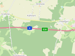
|
blue highway green european road |
| tracesmap.com © |