Key:yett_hole
Jump to navigation
Jump to search
 |
| Description |
|---|
| Part of the defensive system of a medieval doorway |
| Used on these elements |
| Requires |
|
|
| See also |
| Status: in use |
| Tools for this tag |
A yett hole is a hole in a doorway of a castle (like Irish towerhouses) or church through which the chain to hold the yett went. The hole pierces through the entire wall, because the chain has to be fed through it. The yett closed the doorway from the outside, whereas the door opened to the inside.
A study at Queens University Belfast has shown that a yett was more effective than a wooden (oak) door with or without a drawbar[1].
How to map
Map the entrance (entrance=*) and add the key yett_hole=* with the value yes.
You might also want to check the entrance for drawbar slots (drawbar_slot=*).
Examples
-
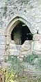 Two yett holes (top and left) at Aghaviller Church/ Castle, Ireland
 -
 Several yett holes (top and sides) at Ballybur Castle, Ireland
 -
 Yett at St Michaels Burgh by Sands in England


