Kurviger
| Kurviger | ||||||||||||||||||||||||||||||||||||||||||||||||||||||||||||||||||||||||||
|---|---|---|---|---|---|---|---|---|---|---|---|---|---|---|---|---|---|---|---|---|---|---|---|---|---|---|---|---|---|---|---|---|---|---|---|---|---|---|---|---|---|---|---|---|---|---|---|---|---|---|---|---|---|---|---|---|---|---|---|---|---|---|---|---|---|---|---|---|---|---|---|---|---|---|
| Author: | Kurviger | |||||||||||||||||||||||||||||||||||||||||||||||||||||||||||||||||||||||||
| Platforms: | Web, Android, and iOS | |||||||||||||||||||||||||||||||||||||||||||||||||||||||||||||||||||||||||
| Version: | 3.5.2 (2024-11-29) | |||||||||||||||||||||||||||||||||||||||||||||||||||||||||||||||||||||||||
| Languages: | German, English, Dutch, French, Italian, and Spanish
| |||||||||||||||||||||||||||||||||||||||||||||||||||||||||||||||||||||||||
| Website: | https://kurviger.com/ | |||||||||||||||||||||||||||||||||||||||||||||||||||||||||||||||||||||||||
| Install: | ||||||||||||||||||||||||||||||||||||||||||||||||||||||||||||||||||||||||||
|
Kurviger makes it easy to plan curvy and exciting motorcycle trips. You can easily navigate your motorcycle rides with the Kurviger App. | ||||||||||||||||||||||||||||||||||||||||||||||||||||||||||||||||||||||||||
| ||||||||||||||||||||||||||||||||||||||||||||||||||||||||||||||||||||||||||
Kurviger is a motorcycle route planner based on GraphHopper. Kurviger (German for more curvy or curvier) prefers curvy and fun roads for motorcyclists, while avoiding cities and highways. Kurviger is capable of calculating roundtrips using a given distance and optionally a heading. Kurviger is available as website, Android app, and iOS app.
For your next motorcycle adventure Kurviger offers a lot routing features to find the perfect route for your riding style. It's possible to define how curvy your route should be, or if you would like to avoid certain types of roads. So it's possible to avoid main roads or narrow roads, depending on your needs. All the basic features for route planning are available for free. For more advanced usage there are premium plans available. More details about the features can be found in the Kurviger documentation.
The Kurviger motorcycle navigation app is available on Google Play and Apple App Store. The Kurviger app is not only a motorcycle navigation app but allows to plan your next motorcycle adventure with features like A to B routing, round-trips, import and export of common route formats like GPX.
Motorcycle Contributions to OSM
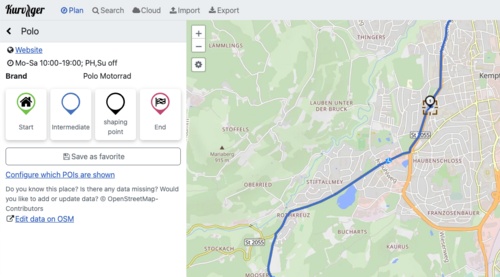
Most routing software tries to find the fastest way to the motorway and route along the motorway. Kurviger however, tries to use curvy backcountry roads where possible. Also, Kurviger enforces motorcycle access rules and not car access rules. Due to that we find a lot of minor issues in the OSM data that might not be found by other routers. Kurviger makes it easy to edit data in OSM. You can right click on the map and open the exact same map view on the OSM website. In addition to that, for some of the more advanced features like POIs or road closures, we offer links to the OSM id to make this even easier.
All of our data sources are updated frequently to reflect changes as soon as possible. Routing data is updated multiple times per week. The maps we host ourselves (currently:"Kurviger Liberty","Kurviger OSM") are updated daily. POIs are updated minutely.
Points of Interest (POI)
Kurviger uses OSM data to show POIs. We show POIs that are important to plan a great motorcycle trip. This includes fuel stations, mountain passes, viewpoints, tourist attractions, repair shops, and more. There is a direct link in every POI widget that leads to the corresponding OSM node/way to make improving the data easier for users of Kurviger. The data is updated minutely.
Usage of the API
The Kurviger API is available as part of the GraphHopper API. This makes it easy to set up a motorcycle routing or navigation application. More information can be found in the Kurviger Wiki or in the GraphHopper Directions API documentation. Feel free to contact Kurviger or GraphHopper and we will set up a matching plan for your needs.
SRTM Mirror
Kurviger provides a mirror for the SRTM data. Feel free to use it.

