MAPPedplanet
Jump to navigation
Jump to search
| mAPPedplanet | ||||||||||||||||||||||||||||||||||||||||||||||||||||||||||||||||||||||||||||||||||||||||||||||||||||||||
|---|---|---|---|---|---|---|---|---|---|---|---|---|---|---|---|---|---|---|---|---|---|---|---|---|---|---|---|---|---|---|---|---|---|---|---|---|---|---|---|---|---|---|---|---|---|---|---|---|---|---|---|---|---|---|---|---|---|---|---|---|---|---|---|---|---|---|---|---|---|---|---|---|---|---|---|---|---|---|---|---|---|---|---|---|---|---|---|---|---|---|---|---|---|---|---|---|---|---|---|---|---|---|---|---|
| Author: | Marcel Gladebeck | |||||||||||||||||||||||||||||||||||||||||||||||||||||||||||||||||||||||||||||||||||||||||||||||||||||||
| License: | Proprietary (free, paid) | |||||||||||||||||||||||||||||||||||||||||||||||||||||||||||||||||||||||||||||||||||||||||||||||||||||||
| Platform: | Android | |||||||||||||||||||||||||||||||||||||||||||||||||||||||||||||||||||||||||||||||||||||||||||||||||||||||
| Status: | Broken | |||||||||||||||||||||||||||||||||||||||||||||||||||||||||||||||||||||||||||||||||||||||||||||||||||||||
| Version: | 3.9.1 (2014-05-12) | |||||||||||||||||||||||||||||||||||||||||||||||||||||||||||||||||||||||||||||||||||||||||||||||||||||||
| Languages: | English and German
| |||||||||||||||||||||||||||||||||||||||||||||||||||||||||||||||||||||||||||||||||||||||||||||||||||||||
| Website: | http://www.mappedplanet.com/mobileinfo | |||||||||||||||||||||||||||||||||||||||||||||||||||||||||||||||||||||||||||||||||||||||||||||||||||||||
| Install: | ||||||||||||||||||||||||||||||||||||||||||||||||||||||||||||||||||||||||||||||||||||||||||||||||||||||||
|
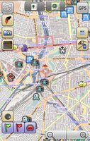
Online/Offline map viewer (own area vector maps with special informations), many standard tools build in | ||||||||||||||||||||||||||||||||||||||||||||||||||||||||||||||||||||||||||||||||||||||||||||||||||||||||
| ||||||||||||||||||||||||||||||||||||||||||||||||||||||||||||||||||||||||||||||||||||||||||||||||||||||||
mAPPedplanet ([1])
App for tourist information and much more.
Features
- Offline maps of the world available for download
- 4 different map types based on Openstreetmap
- 6 different map themes for offline maps
- More than 100 different overlays/categories (7 overlays in the FREE version) from different sources with data from tourism, eat and drink, accommodation, transport and much more - online and offline
- Roads, Public Transport and tourist routes that are visible can be listed and marked on the map
- Wikipedia
- Route planner (car, bicycle, walk) with off-line navigation and voice
- Tracking with import and export function
- Own data import and export feature
- Photo-tagging, Compass, Google Streetview
- Augmented Reality for overlays/categories and routing (*)
Categories as overlays:
- Hotels/Hostels (*)
- Attractions/Points Of Interest (*)
- Camping
- Restaurant (*)
- Swimming Pool
- Fast Food (*)
- Tourist Info
- Hospital
- Supermarket
- Bank
- ATM
- Cafe (*)
- Pub/Bar (*)
- Club/Disco (*)
- Car Sharing
- Car Rental
- Station
- Bus Station
- Fuel Station
- Police
- Post Office
- Currency Exchange
- Rest Area
- Toll Booth
- Laundry
- Shopping Mall
- Beach
(*) also FREE-Version There are also more than 80 categories available only for Offline Maps
