Nadoloni Editor
| nadoloni Editor | ||||||||||||||||||||||||||||||||||||||||||||
|---|---|---|---|---|---|---|---|---|---|---|---|---|---|---|---|---|---|---|---|---|---|---|---|---|---|---|---|---|---|---|---|---|---|---|---|---|---|---|---|---|---|---|---|---|
| Author: | Oleh Zamkovyi | |||||||||||||||||||||||||||||||||||||||||||
| License: | WTFPL | |||||||||||||||||||||||||||||||||||||||||||
| Platform: | Web | |||||||||||||||||||||||||||||||||||||||||||
| Version: | 1.0 (2014-12-16) | |||||||||||||||||||||||||||||||||||||||||||
| Language: | English
| |||||||||||||||||||||||||||||||||||||||||||
| Website: | ||||||||||||||||||||||||||||||||||||||||||||
| Programming language: | PHP | |||||||||||||||||||||||||||||||||||||||||||
|
Web-based OSM data editor | ||||||||||||||||||||||||||||||||||||||||||||
| ||||||||||||||||||||||||||||||||||||||||||||
nadoloni Editor - This is a browser tag editor that works with preloaded OSM data.
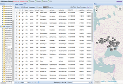
The service loads current OSM data (per hour/day) and processes them (for example: road segments and houses are combined into streets, POIs are attached to houses (addressing), etc.). As a result, users get the opportunity to work with more complex objects using the spreadsheet interface:
- View objects with their attributes in a tabular form and visualize them on the map.
- Filtering, sorting, grouping, validating and searching for objects by their properties
- Ability to edit tags
- Backlighting errors and objects on the map
Using the service functionality, user can not edit the geometry, but gets the opportunity to edit tags of many similar objects scattered geographically over long distances. For example, the operation "find all gas stations and specify for each contact phone" using the classic method (JOSM or analogs) will take much more time than editing one column of the spreadsheet.
