OSG-Maps
Android App for displaying 3D Maps based on OpenStreetMap
| OSG-Maps | ||||||||||||||||||||||||||||||||||||||||||||||||||||||||||||||||||||||||||||||||||||||||||||||||||||||||
|---|---|---|---|---|---|---|---|---|---|---|---|---|---|---|---|---|---|---|---|---|---|---|---|---|---|---|---|---|---|---|---|---|---|---|---|---|---|---|---|---|---|---|---|---|---|---|---|---|---|---|---|---|---|---|---|---|---|---|---|---|---|---|---|---|---|---|---|---|---|---|---|---|---|---|---|---|---|---|---|---|---|---|---|---|---|---|---|---|---|---|---|---|---|---|---|---|---|---|---|---|---|---|---|---|
| Author: | Aschilli | |||||||||||||||||||||||||||||||||||||||||||||||||||||||||||||||||||||||||||||||||||||||||||||||||||||||
| License: | Proprietary (4,99EUR) | |||||||||||||||||||||||||||||||||||||||||||||||||||||||||||||||||||||||||||||||||||||||||||||||||||||||
| Platform: | Android | |||||||||||||||||||||||||||||||||||||||||||||||||||||||||||||||||||||||||||||||||||||||||||||||||||||||
| Status: | Broken | |||||||||||||||||||||||||||||||||||||||||||||||||||||||||||||||||||||||||||||||||||||||||||||||||||||||
| Version: | 1.4.2 (2016-12-07) | |||||||||||||||||||||||||||||||||||||||||||||||||||||||||||||||||||||||||||||||||||||||||||||||||||||||
| Language: | English
| |||||||||||||||||||||||||||||||||||||||||||||||||||||||||||||||||||||||||||||||||||||||||||||||||||||||
| Website: | - | |||||||||||||||||||||||||||||||||||||||||||||||||||||||||||||||||||||||||||||||||||||||||||||||||||||||
| Programming language: | Java | |||||||||||||||||||||||||||||||||||||||||||||||||||||||||||||||||||||||||||||||||||||||||||||||||||||||
|
OpenStreetMap 3D on Android | ||||||||||||||||||||||||||||||||||||||||||||||||||||||||||||||||||||||||||||||||||||||||||||||||||||||||
| ||||||||||||||||||||||||||||||||||||||||||||||||||||||||||||||||||||||||||||||||||||||||||||||||||||||||
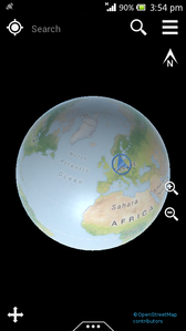
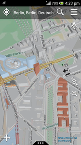
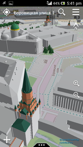
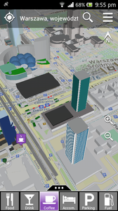
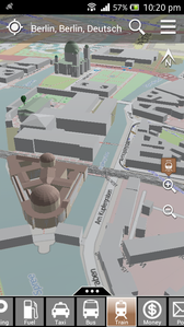
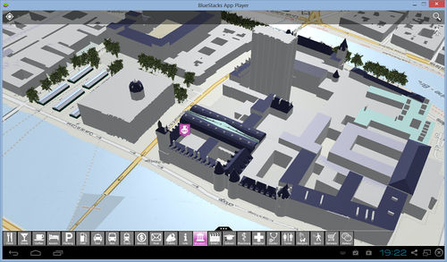
OSG-Maps displays the OpenStreetMap map on a virtual globe in 3D. Great for navigating in the city and yellow pages search. Buildings are displayed as 3D bodies including roof shapes. By using the integrated 3D acceleration on the device, a very smooth navigation in the map is achieved. The transitions between zoom level is seamless - there is no switching between different display modes.
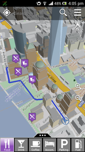
OSG-Maps provides search functions for addresses and POIs (Points of Interest). Searching for POIs is a great function for finding interesting facilities and places. For example, all nearby restaurants can be displayed on the map while strolling through the town. Moreover, many POI entries contain detailled information on opening hours, type of facility, contact address, telephone numbers, and accessibility for wheelchair users.
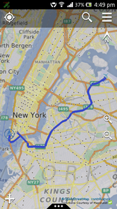
Routes can be computed from the current GPS location to POIs within a range of 200km. They can be computed for cars, bicycles and pedestrians taking into account turn restrictions.
OSG-Maps fetches all maps and data live from the internet. Thus, all content is always up-to-date. By using compression for downloading data, the required data volume and used bandwidth is limited.
Features
- Display of buildings in 3D
- Optional display of Trees in 3D
- Choice between different map styles
- Car, bicycle and pedestrian routing
- 2 navigation modes: pan, rotate
- Distortion-free map display (no map projection!)
- Display optimized for smart phones and tablets
- Display of the accurate GPS position or approximate position bsed on cells or Wifi hot spots
- Global search function for addresses
- Search for POIs in the following categories: eating, drinking, cafes, accomodation, parking, fuel stations, taxi, bus and train stations, ATMs, post, public facilities, info booths, museums, entertainment, schools, pharmacies, hospitals, physicians, public toilets, churches, sport facilities, convenience stores, bakeries
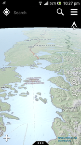
Screenshots
Running OSG-Maps on Windows
It is perfectly possible to run 3D Android Apps on Windows machines. The best option is to use the Android emulator from BlueStacks. Other emulators work in principle, but lack proper GPU support, which is absolutely necessary for this App. You will need a Google account for logging into the Play Store and download the installation package. As free software, BlueStacks will download additional Apps from time to time (mostly games). But don't worry, this is quite unobstrusive and they will not be installed on your other Android devices.
Go to http://www.bluestacks.com, download and install the BlueStacks App Player. Keep App store access enabled during the installation process. The player is started right away after installation is complete and a custom Android home screen shows up. On the upper left side, hit the search button and start searching in the Play Store. You need to complete some steps in order to get connected. Enable AppStore, continue and register with your Google account or create one. You don't need to enable any of the Google services. On the next screen you need to log in again. It will ask for your password twice. Now you are in the Play Store and you can install any software you like. Search and Install OSG-Maps.

