This article or section may contain
out-of-date information. The information may no longer be correct, or may no longer have relevance.
If you know about the current state of affairs, please help keep everyone informed by updating this information. (
Discussion)
| OSM2Palm
|
|
|
| Author:
|
Karl Meyer
|
| License:
|
GNU GPL
|
| Platforms:
|
Windows and Palm OS
|
| Status:
|
Broken
|
| Version:
|
1.6 (2009-05-24)
|
| Language:
|
English
|
| Website:
|
???
|
| Source code:
|
http://
|
| Programming language:
|
HB++
|
Features
| Feature
|
Value
|
| Map Display
|
| Display map
|
yes
|
| Map data
|
raster
|
| Source
|
offline
|
| Rotate map
|
?
|
| 3D view
|
no
|
| Shows website
|
?
|
| Shows phone number
|
?
|
| Shows operation hours
|
?
|
| Routing
|
| Routing
|
no
|
| Create route manually
|
?
|
| Calculate route
|
?
|
| Create route via Waypoints
|
?
|
| Routing profiles
|
?
|
| Turn restrictions
|
?
|
| Calculate route without Internet (Offline routing)
|
?
|
| Routing providers
|
?
|
| Avoid traffic
|
?
|
| Traffic Provider
|
?
|
| Navigating
|
| Navigate
|
no
|
| Find location
|
?
|
| Find nearby POIs
|
?
|
| Navigate to point
|
?
|
| Navigation with voice / Voice guidance
|
?
|
| Keep on road
|
?
|
| Lane guidance
|
?
|
| Works without GPS
|
?
|
| Navigate along predefined route
|
?
|
| Tracking
|
| Make track
|
yes
|
| Customizable log interval
|
?
|
| Track formats
|
?
|
| Geotagging
|
?
|
| Fast POI buttons
|
?
|
| Upload GPX to OSM
|
?
|
| Monitoring
|
| Monitoring
|
yes
|
| Show current track
|
yes
|
| Open existing track
|
yes
|
| Altitude diagram
|
?
|
| Show POD value
|
?
|
| Satellite view
|
?
|
| Show live NMEA data
|
?
|
| Show speed
|
?
|
| Send current position
|
?
|
| Editing
?
|
| Rendering
?
|
| Accessibility
?
|
|
|
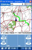
OSM2PALM is a set of applications for the PALM PDAs in cooperation with Windows PCs. The PALM application is called Osmtiles.
- Developer: Karl Meyer
- License Type: Freeware
- Target platform: PalmOS 4.x und Windows
- Dev. tools: HB++ und VB5
Features
The set consists of a Windows application to download the tiles from the internet and convert them.
The Palm application displays the tiles on the PALM and display the current position of an attached Bluetooth GPS. Additionally, POIs can be saved into a GPX file.
For more details please see at the homepage of the program.
Download
