OSMNavigator
Jump to navigation
Jump to search
OSMNavigator is a software capable of render, edit, navigate, route over OpenStreetMap Data. (https://github.com/MKergall/osmbonuspack ?)
Main Features:
- based on QT Library 4.x
- support for all major databases with qt sql driver (actually mysql is experimental, use postgres instead)
- it can manage gigabytes and gigabytes of data
- rendering is based on a modifiable set of rules applied to nodes, segments, ways, areas...
- ruleset can be saved and loaded in customizable ruleset profiles
- ruleset can be different among zoom levels
- you can save an image of the current vieweble area
- you can do an area rendering over a high resolution box and save it to a file
- WYSWYG Editor, while editing you'll get what you see
- Search Node from db tags or from geonames.org
- other ...
-
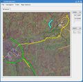 OSMNavigator showing an area in browse mode with landsat plugin
 -
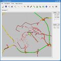 OSMNavigator showing an area in edit mode

