OSMTrack
Jump to navigation
Jump to search
| OSMTrack | ||||||||||||||||||||||||||||||||||||||||||||||||||||||||||||||||||||||||||||||||||||||||||||||||||||||||
|---|---|---|---|---|---|---|---|---|---|---|---|---|---|---|---|---|---|---|---|---|---|---|---|---|---|---|---|---|---|---|---|---|---|---|---|---|---|---|---|---|---|---|---|---|---|---|---|---|---|---|---|---|---|---|---|---|---|---|---|---|---|---|---|---|---|---|---|---|---|---|---|---|---|---|---|---|---|---|---|---|---|---|---|---|---|---|---|---|---|---|---|---|---|---|---|---|---|---|---|---|---|---|---|---|
| Author: | Dmitri Toropov | |||||||||||||||||||||||||||||||||||||||||||||||||||||||||||||||||||||||||||||||||||||||||||||||||||||||
| License: | Proprietary (0,99$) | |||||||||||||||||||||||||||||||||||||||||||||||||||||||||||||||||||||||||||||||||||||||||||||||||||||||
| Platform: | iPhone | |||||||||||||||||||||||||||||||||||||||||||||||||||||||||||||||||||||||||||||||||||||||||||||||||||||||
| Status: | Broken | |||||||||||||||||||||||||||||||||||||||||||||||||||||||||||||||||||||||||||||||||||||||||||||||||||||||
| Version: | 3.0.3 (2011-12-30) | |||||||||||||||||||||||||||||||||||||||||||||||||||||||||||||||||||||||||||||||||||||||||||||||||||||||
| Languages: | English, German, and French
| |||||||||||||||||||||||||||||||||||||||||||||||||||||||||||||||||||||||||||||||||||||||||||||||||||||||
| Website: | http://itunes.apple.com/app/osmtrack/id295625255?mt=8 | |||||||||||||||||||||||||||||||||||||||||||||||||||||||||||||||||||||||||||||||||||||||||||||||||||||||
|
Easy to use tracking app with offline, user-updateable vector map and direct upload to OpenStreetMap | ||||||||||||||||||||||||||||||||||||||||||||||||||||||||||||||||||||||||||||||||||||||||||||||||||||||||
| ||||||||||||||||||||||||||||||||||||||||||||||||||||||||||||||||||||||||||||||||||||||||||||||||||||||||
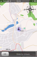
OSMTrack is an iPhone tracking app designed specifically for contributing to OpenStreetMap. The main design objectives were to make It is easy to use, with "single-button-interface", and fast.
The main features provided by the current version are:
- Maps. Maps are offline, rendered on the device from vector data, and downloadable in real time directly from the OpenStreetMap server. Offline means you don't depend on whether you have a connection, e.g. you see the map also on an iPod Touch with TomTom car kit (though this combination is not officially supported people have reported it to work fine). Rendered from vector data means that a lot more data will take a lot less space than if when you would use pre-rendered tiles, but don't start to download the complete world, it takes a lot of time to "compile" the XML vector data obtained from the server into the internal application format - try a small region first to get an idea of how long it takes on your device really. Downloadable in real time from the OSM server means that you don't need to wait for anyone to render new tiles for the changes you made in the map - just download the data and you have the most recent map.
- Zoom- and pan-capable graphical track view.
- Direct upload to the OpenStreetMap account as well as sending tracks per email.
- Diplay points from all tracks in the vicinity. This feature allows you to see where you have already been.
- Multiple tracks.
- Universal iPhone / iPad app.
- Screen lock for in-pocket use for iPhone 3G (does not support multitasking), full multitasking support for the devices that support it (iPhone 3Gs, iPhone 4, iPad).
- Preliminary support for waypoints. That means that displaying the waypoints during logging is not optimal yet, neither you can rename them or do anything, but you do can add waypoints.
