OpenTripPlanner (Android)
| OpenTripPlanner for Android | ||||||||||||||||||||||||||||||||||||||||||||||||||||||||||||||||||||||||||||||||||||||||||||||||||||||||
|---|---|---|---|---|---|---|---|---|---|---|---|---|---|---|---|---|---|---|---|---|---|---|---|---|---|---|---|---|---|---|---|---|---|---|---|---|---|---|---|---|---|---|---|---|---|---|---|---|---|---|---|---|---|---|---|---|---|---|---|---|---|---|---|---|---|---|---|---|---|---|---|---|---|---|---|---|---|---|---|---|---|---|---|---|---|---|---|---|---|---|---|---|---|---|---|---|---|---|---|---|---|---|---|---|
| Authors: | Center for Urban Transportation Research, University of South Florida | |||||||||||||||||||||||||||||||||||||||||||||||||||||||||||||||||||||||||||||||||||||||||||||||||||||||
| License: | Apache License v2.0 | |||||||||||||||||||||||||||||||||||||||||||||||||||||||||||||||||||||||||||||||||||||||||||||||||||||||
| Platform: | Android | |||||||||||||||||||||||||||||||||||||||||||||||||||||||||||||||||||||||||||||||||||||||||||||||||||||||
| Status: | Broken | |||||||||||||||||||||||||||||||||||||||||||||||||||||||||||||||||||||||||||||||||||||||||||||||||||||||
| Version: | v2.1.5 (2017-04-20) | |||||||||||||||||||||||||||||||||||||||||||||||||||||||||||||||||||||||||||||||||||||||||||||||||||||||
| Languages: | English, German, Spanish, French, Galician, Portuguese, and Romanian
| |||||||||||||||||||||||||||||||||||||||||||||||||||||||||||||||||||||||||||||||||||||||||||||||||||||||
| Website: | https://github.com/CUTR-at-USF/OpenTripPlanner-for-Android/wiki | |||||||||||||||||||||||||||||||||||||||||||||||||||||||||||||||||||||||||||||||||||||||||||||||||||||||
| Install: | ||||||||||||||||||||||||||||||||||||||||||||||||||||||||||||||||||||||||||||||||||||||||||||||||||||||||
| Source code: | https://github.com/CUTR-at-USF/OpenTripPlanner-for-Android/ | |||||||||||||||||||||||||||||||||||||||||||||||||||||||||||||||||||||||||||||||||||||||||||||||||||||||
| Programming language: | Java | |||||||||||||||||||||||||||||||||||||||||||||||||||||||||||||||||||||||||||||||||||||||||||||||||||||||
|
An Android app for multi-modal trip planning using any OpenTripPlanner server |
||||||||||||||||||||||||||||||||||||||||||||||||||||||||||||||||||||||||||||||||||||||||||||||||||||||||
| ||||||||||||||||||||||||||||||||||||||||||||||||||||||||||||||||||||||||||||||||||||||||||||||||||||||||
This project is an open-source Android client for the OpenTripPlanner project. It is designed to interface with any OpenTripPlanner server via the OTP RESTful API [1].
A list of public OTP servers is kept in the OTP Server Directory [2] (a Google Docs spreadsheet), and all mobile clients will be able to plan trips automatically using whichever server is appropriate for their current location. Please contact Sean Barbeau at barbeau@cutr dot usf.edu if you'd like to add your OTP server to the directory.
Download the App!
Download the app via the Google Play store [3].
See the Release Notes [4] for version details.
Current Features
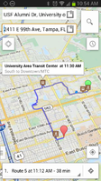
- Plan trips via bus, bike, and walk that are linked together (i.e., multi-modal trips)
- Draggable markers for start/end locations
- Sliding panel for trip options, including bike options (called "Bike triangle" on the OTP website), allowing custom bike trips to balance how quick, flat, and "bike-friendly" trip results are
- Options to change wheelchair accessibility, max walk distance, etc.
- Trip itinerary displayed both on the map with markers for transitioning modes, to show info for the next mode, place and time when tapped, as well as a list of step-by-step directions.
- Options for various map tile providers including OSM and Google.
- Options for various Point-of-Interest search, including geo-coding, providers
- Auto-detection of closest OTP server based on the OTP Server Directory [5] (Can also use a custom URL to any OTP server REST API)
- Feedback email for Android client maintainer or to particular OTP server maintainer
- Date and time support to plan a trip to an specific departure/arrival time.
- Saves your battery! Low energy consumption by using the Google Play Services fused location provider [6] for location information.
Future features
- Add elevation graph
- Real-time navigation support, including auto-rerouting
- Text-to-Speech directions
- Text localization
- Favorites management for most common departures/destinations.
See our Github "Issues" page [7] for a full list of planned features, which are labeled with an "Enhancements" tag.
Developers
If you'd like to get your own version of the app working based on the source code, check out our Developer Guide page [8].
We'd love to work with other developers who might be interested in knocking off one or two of the above planned features. Please let us know if you're interested in helping out by emailing Sean Barbeau at barbeau@cutr dot usf.edu.
Some development was done as part of the Google Summer of Code 2013 OTP for Android project [9]!
Mailing List - OpenTripPlanner Developer list [10] - Just be sure to mention "OTP Android" in the subject line.
Acknowledgements
Please see our Acknowledgements page [11]!
Support
For support see: our main Github wiki [12]
