Proposal:Church direction
| Church direction | |
|---|---|
| Proposal status: | Draft (under way) |
| Proposed by: | Sykul |
| Draft started: | 2025-04-07 |
Proposal
To apply the existing direction tag to the direction the altar is pointing in Christian churches. Modern churches may be designed, or remodelled, so that the altar isn't pointing in the architectural orientation of the building, rather pointing in the opposite direction towards the congregation (a configuration known as ![]() versus populum). However, even in such situations, the side of the building on which the altar is located may be considered the architectural 'direction' of the church.
versus populum). However, even in such situations, the side of the building on which the altar is located may be considered the architectural 'direction' of the church.
Rationale
Church orientation, in other words in which cardinal direction the altar is pointing, is a notable and symbolically important feature in traditional Christian architecture. It may be of interest to Christians and researchers.
This kind of data has been used in statistical historical studies so there is value to adding it to the database.
There is an existing tag which suits this purpose well, is easily understandable by mappers and data users, and can easily be applied to this context without confusion.
It can be inferred from satellite imagery as well as surveys on the ground using a simple phone or magnetic compass.
Tagging
Similarly to the regular use of direction tags.
| Value | Element | Description |
|---|---|---|
| <number> | The given number specifies the degrees from 0 to 359 in which the altar is pointing, or the angle from the opposite side of the building towards the altar, where 0 is equal to northward, using clockwise rotation. | |
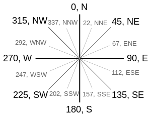
| <abbreviation> | One of the cardinal directions, ordinal directions, or secondary intercardinal directions, specified as its abbreviation using uppercase characters [NWSE], e.g. NE means north-east. See the image below for all possible values and their meaning.
| |
| <cardinal> | One of the four cardinal directions, spelled out in lowercase. That is, north, east, south, or west.
|
This image shows all possible values for direction abbreviations together with the corresponding degrees.
Examples
https://www.openstreetmap.org/way/101047347
Rendering
No need for any special rendering. It is mostly for statistical and historical interest.
Features/Pages affected
External discussions
Comments
Please comment on the discussion page.
