Proposal:Hearing loop
| Hearing loop | |
|---|---|
| Proposal status: | Draft (under way) |
| Proposed by: | AlephNull |
| Tagging: | hearing_loop=yes, hearing_loop=limited, hearing_loop=no
|
| Applies to: | |
| Definition: | Indicate the presence of a hearing induction loop, a particular type of assistive listening technology. |
| Statistics: |
|
| Draft started: | 2021-12-20 |
Proposal
Proposed is the key hearing_loop=*. The main value is yes, indicating that a feature has a ![]() hearing induction loop. The secondary values
hearing induction loop. The secondary values limited and no can be used for partial availability or relevant absence.
Rationale
Hearing loops are an assistive listening technology. They can be deployed as whole-room systems or as smaller systems integrated into counters. Whole-room systems can be found in auditoriums, churches, cinemas, and other large public places. Counter-integrated systems can be found at ticket booths, information desks, and in government offices, easing communication in potentially difficult listening conditions. Some jurisdictions require assistive listening or hearing enhancement systems in certain newly built or renovated buildings or spaces. In some cases the rule specifically requires an induction loop, while in others an induction loop is only one permitted assistive listening technology.
Mapping hearing loops enables users of telecoil-equipped hearing aids and cochlear implants to choose between POIs based on the presence of hearing loops (e.g. when choosing a cinema). An open database of hearing loops could also be useful for visualizing progress in making public spaces and transportation accessible. Local advocacy groups often maintain small databases of hearing loops, but there seem to be no global and easily editable databases for hearing loops. These smaller databases are also usually not well integrated with other map data. In August 2022, Google Maps began adding information about hearing loops, so users may come to expect this information to be available in online maps.
There already exists sporadic tagging of hearing loops in the OSM database.
Some are mapped with description tags such as deaf:description:en=* only.
hearing_impaired:induction_loop=*
|
|
induction_loop=*
|
|
hearing_loop=*
|
|
audio_loop=*
|
Key name
The key induction_loop=* could be potentially ambiguous, since there are other types of induction loops, some of which may be relevant to OpenStreetMap. For example, induction loops are sometimes used to detect traffic.
The key audio_loop=* has seen usage, especially in France, for the same real-world feature.
However, it is not a typical English term for hearing loops.
It also does not return useful information when searched for on the internet,
which may leave people confused about the meaning of the tag.
Existing uses of audio_loop=yes should generally be interpreted as referring to hearing loops.
This proposal does not require retagging existing objects, but recommends hearing_loop=yes for new mapping because it is clearer to English-speaking mappers and less likely to be confused with unrelated audio-loop concepts.
A longer or namespaced key would be unwieldy.
hearing_loop=* is the shortest mostly unambiguous key name.
Tag values
The main value is yes, indicating that a hearing loop is present and intended for use.
The value limited can be used for features with multiple functionally separate areas or services where only some have hearing loops.
For example, a cinema where not all screening rooms have hearing loops could be tagged with hearing_loop=limited.
However, a church where only the balcony seats lack coverage would normally still be tagged with hearing_loop=yes, with the caveat described separately if useful.
The value no may be used for features where the presence of a hearing loop may be expected by users or specifically required by local rules, but is not present.
Use hearing_loop=no with caution, and only where the absence of a hearing loop is relevant accessibility information.
For example, it may be useful for a venue type or region where hearing loops are common or legally expected, but not where almost no comparable features have hearing loops.
Only yes, limited, and no are proposed here.
Caveats about the coverage or quality of a hearing loop can be added with a language-qualified description tag, for example deaf:description:en=Loop only works at the information desk.
Tagging
The tag should be added to the feature whose use is made accessible by the hearing loop.
Prefer the smallest separately mapped feature that is useful to data consumers, for example an information desk, ticket counter, room, platform, auditorium, or venue.
If the loop serves the venue as a whole, or if only the venue is mapped, tag the venue.
Where only some separately usable parts of a larger feature have hearing loops, either tag those parts directly or use hearing_loop=limited on the larger feature.
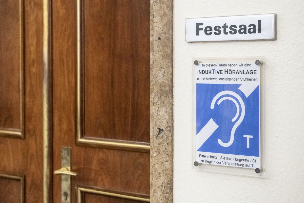
For the purposes of this proposal, a hearing loop is an audio-frequency induction loop system for hearing aid purposes. Such systems transmit sound by an audio-frequency magnetic field that can be received directly by telecoil-equipped hearing aids or cochlear implant processors switched to a telecoil ("T") setting. Mappers are not expected to verify compliance with technical standards.
Usually there will be signage or official information advertising the hearing loop. The ISO 7001 public information symbol for a hearing loop is PI AC 015, "Loop for the hearing impaired", often shown as an ear symbol with a "T". In some jurisdictions, generic assistive-listening signage may be used for induction loop, infrared, FM/radio, or hard-wired systems. Do not infer hearing_loop=yes from generic assistive-listening signage unless the signage or another source specifically indicates a hearing loop, induction loop, audio induction loop, T-loop, telecoil/T-coil loop, or AFILS.
Do not use hearing_loop=yes for other assistive listening technologies, such as FM/radio, infrared, Bluetooth LE Audio/Auracast, Wi-Fi or app-based audio streaming systems, hard-wired headsets, or ordinary public-address systems. The availability of receivers, headphones, earbuds, or neckloops for another system is also not sufficient.
A Disabilitydescription such as deaf:description:en=* can be used for more detailed tagging of a hearing loop, since the coverage and quality of systems can vary in ways that would be hard to capture in a reasonably compact tagging scheme, or would require extensive indoor mapping.
Relevant standards and guidance
The main international performance standard for hearing loops is IEC 60118-4:2014+AMD1:2017 CSV ("Electroacoustics - Hearing aids - Part 4: Induction-loop systems for hearing aid purposes - System performance requirements"). It specifies requirements such as magnetic field strength and frequency response for audio-frequency induction-loop systems used with telecoils. Mappers are not expected to verify compliance with this or any other technical standard.
Other IEC publications cover related technical details. IEC 62489-1 covers system components such as loop driver amplifiers, microphones, and other audio components. IEC 62489-2 covers assessment of low-frequency magnetic field emissions. IEC TR 63079 gives recommendations for the design, planning, installation, testing, operation, and maintenance of hearing-loop systems.
In Europe, IEC 60118-4:2014 and its amendment have been adopted through EN 60118-4:2015 and EN IEC 60118-4:2015/A1:2018, with national implementations such as DIN EN IEC 60118-4:2018-08 and BS EN IEC 60118-4:2015+A1:2018.
In the United States, the 2010 ADA Standards require assistive listening systems in certain assembly areas, but distinguish induction loop, infrared, FM radio transmission, and hard-wired systems. The ADA Standards therefore should not be read as requiring hearing_loop=yes for all assistive listening systems.
Examples
Example Tagging
| image | tagging |
|---|---|

|
|

|
|

|
|

|
|
| https://uni-tuebingen.de/fileadmin/_processed_/8/2/csm_Induktive_H%C3%B6ranlage__2__f9839d3146.jpg |
|

|
|
Examples of existing resources or maps listing hearing loops
- Switzerland: https://hoeranlagen.ch
- Germany: https://www.schwerhoerigen-netz.de/induktive-hoeranlagen
- Christchurch (NZ): https://ccc.govt.nz/culture-and-community/strengthening-communities/accessibility-map
Rendering
As with wheelchair=*, most map styles won't render hearing_loop=*.
Special purpose maps and infoboxes may show a pictogram similar to the ISO 7001 symbol PI AC 015.
Features/Pages affected
- Disabilitydescription
- How to map for the needs of people with disabilities
- Pages for features that commonly have hearing loops may also mention
hearing_loop=*, ideally grouped together with other accessibility tags such aswheelchair=*. Examples includeamenity=place_of_worship,indoor=room,tourism=information, andhighway=elevator.
Comments
Please comment on the discussion page.