Proposal:Lane directions
| Lane directions | |
|---|---|
| Proposal status: | Abandoned (inactive) |
| Proposed by: | nyoma |
| Tagging: | lane_directions=1:R,S;2:S;3:S |
| Applies to: | IconWay |
| Definition: | directions on intersections |
| Statistics: |
|
| Rendered as: | 
|
| Draft started: | |
| Proposed on: | 2010-05-28 |
| Vote end: | * |


Summary
This tag shows allowed directions to drive through the intersection.
How to Map
Add lane_directions=1:R,2:S;3:S to an existing highway with two or more lanes on the last segment before the intersection to show allowed directions to drive through this intersection. Number stands for the number of lane, letters mean directions: L - left turn, R - right turn, SL - sharp left turn, SR - sharp right turn, HL - half left turn, HR - half right turn, S - straight, LU - left U-turn, RU - right U-turn. If a lane has more than one directions to drive, these directions should be separated by comma lane_directions=1:R,S;2:S;3:S. If there are more than one crossing on an intersection, and directions of driving are being changed after the first crossing, one more node may be added on the segment following by the first crossing, or you may use the whole segment between crossings. But there is a question to discuss: where one should begin to count lanes - from the left or from the right? In Ukraine we start from the rightmost lane.
Should be rendered at 2 or 3 zoom levels.
Examples

Directions samples:

Half Left turn and Straight ahead
Half Left turn
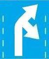
Half Right turn and Sharp Right turn
Half Right turn
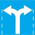
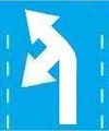
Left turn and Right turn

Left turn and Straight ahead
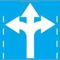
Left turn, Right turn and Straight ahead
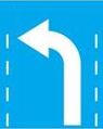
Left turn
Left U-turn and Straight ahead
Left U-turn
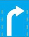
Right turn
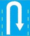
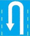
Right U-turn
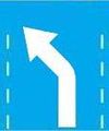
Sharp Left turn and Half Left turn

Sharp Left turn and Straight ahead

Sharp Left turn

Sharp Right turn
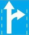
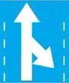
Straigh ahead and Right turn
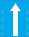
Straigh ahead
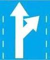
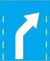
Straight ahead and Half Right turn
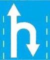
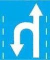
Straight ahead and Right U-turn
Straight ahead and Sharp Right turn


