Proposal:Runway holding position
| Runway Holding Position | |
|---|---|
| Proposal status: | Canceled (inactive) |
| Proposed by: | Tapestes |
| Tagging: | aeroway=rwy_holding_position
|
| Statistics: |
|
| Draft started: | 2019-03-28 |
| RFC start: | 2019-03-28 |
Proposal

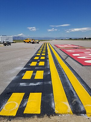
Proposing the addition of runway holding position markings (commonly called hold lines). Runway holding position markings are painted markings on an airport surface that identify the runway safety area. At controlled airports, these markings indicate where an aircraft is to stop if the aircraft does not have permission to enter the runway. When exiting a runway, an aircraft is not considered clear of that runway until all parts of the aircraft have crossed the holding position marking. The runway holding position is painted across the runway or taxiway and consists of two solid lines on the side that is clear of the runway safety area and two dashed lines on the other side. You can view an annotated image of the runway safety area, including runway position markings, here.
Rationale
The runway holding position marking is critical to airmen navigating the airport surface. In simulation environments, proper rendering of these markings can greatly enhance realism and improve training. Further, failure to hold at the marking as instructed or adequately clear the holding position marking can and has resulted in catastrophic accidents. NASA and others have found that turn-by-turn directions could significantly reduce the number of runway incursions (improper entry into the runway safety area which may create a risk of collision on the ground). Testing these turn-by-turn systems, however, requires detailed airport information, and must include runway holding position markings. In a simulation environment, OSM would provide an excellent data source.
Examples
Runway holding position markings are required in the US and across the world at airports of a given size. Any airport you have traveled in or out of commercially has runway holding position markings. Though difficult to estimate, offhand I would guess there are hundreds of thousands of these markings at airports around the globe.
Tagging
This tag would fall under the aeroway category, which is also used to mark runways, taxiways, and other features that are used for navigating the airport surface. We suggest using the tag aeroway=rwy_holding_position.
Applies to
Ways. Capturing the shape of the holding position marking is important as it neither always a straight line, nor always orthogonal to the taxiway. Examples of can be found at almost any airport (e.g., the departure end of 13R at Dallas Love Field).
Rendering
Can be rendered as shown here
Features/Pages affected
A holding_position tag exists currently, though it is represented as a node and the type of holding position marking is indistinct. It includes, for example, ILS critical area holding positions that are designed to keep large aircraft from blocking instrument landing system signals. Also included are interim holding position markings, which are largely use to control traffic flow on the surface. For turn-by-turn and safety mapping applications, separating out runway holding position markings from other types is an absolute necessity.
External discussions
Comments
Please comment on the discussion page.