Qwant Maps
| Qwant Maps | ||||||||||||||||||||
|---|---|---|---|---|---|---|---|---|---|---|---|---|---|---|---|---|---|---|---|---|
| License: | Apache License 2.0 | |||||||||||||||||||
| Status: | Broken | |||||||||||||||||||
| Website: | https://www.qwant.com/maps/ | |||||||||||||||||||
| Source code: | https://github.com/Qwant/qwantmaps | |||||||||||||||||||
| Programming language: | JavaScript
| |||||||||||||||||||
| ||||||||||||||||||||
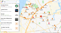
Qwant Maps was map display hosted by the creators of the search engine Qwant (https://www.qwant.com), and developed as open source software.
This maps features was sadly discontinued. See their mention on x.com on 20th May 2024:
Concernant Qwant Maps, le service va bientôt être désactivé. À la place, on a directement intégré un module Maps dans le moteur lorsque vous cherchez un lieu par exemple. Pour le moment, on préfère se concentrer sur l’expérience de recherche via de nouvelles fonctionnalités. On sait que ça ne fait plaisir à personne, nous les premiers, mais on en a longuement discuté et on pense que c’est mieux comme ça
Translation:
Regarding Qwant Maps, the service will soon be disabled. Instead, a Maps module has been directly integrated into the engine when you are looking for a place for example. For the moment, we prefer to focus on the search experience via new features. We know it doesn't please anyone, especially us, but we've been talking about it for a long time and we think it's better this way.
Originally this was a vector map display, mainly using OSM data to render its maps. The web application respects the user's privacy, and claims to never track or sell user data.[1]
The projects featured a location search, visualisation of POI data, as well as car, pedestrian, and bike routing.
The follow github repos remain in place, but presumably their open source development of the map feature will now cease.
Components
- the frontend is called Erdapfel: https://github.com/QwantResearch/erdapfel
- the tileserver is based on Kartotherian: https://github.com/Qwant/kartotherian_docker
- the geocoder is Mimirsbrunn
- the internal backend API is called Idunn: https://github.com/Qwant/idunn
Routing
Quant Maps adds, next to existing foot, car and bike routing a routing service for public transport. However, the service is only available for the major French cities and major European cities. "... disponibles pour les grandes villes de France et les plus grandes villes européennes."[1]
See also
- Announcement of Qwant Maps on 2019-06-27
- Mapcarta
- List of OSM-based services

