Sant Vicenç dels Horts
Jump to navigation
Jump to search

| V・T・E |
| latitude: 41.393552, longitude: 2.009787 |
| Browse map of Sant Vicenç dels Horts 41°23′36.79″ N, 2°00′35.23″ E |
| Edit map |
|
External links:
|
| Use this template for your locality |
Sant Vicenç dels Horts is a city in Catalonia, Spain at latitude 41°23′36.79″ North, longitude 2°00′35.23″ East.
Events
OpenStreetMap for the ADF Baix Llobregat (Forest Defence Association)
- Day: 11th October 2014
- Where: Molí dels Frares
- Hour: 10:00 to 13:00
Baix Llobregat's ADF Federation
OpenStreetMap for the Unió de Botiguers
- Workshop's date will be defined in the next months
OpenStreetMap in Sant Vicenç dels Horts
Carlos Sánchez: This is the first event dedicated to OpenStreetMap performed in the city. An introductory presentation about OSM and map editing will be held the first day. A workshop about OSM editing and solving doubts will be held the second day.
- Day: May 27th and 29th, 2014
- Location: Molí dels Frares
- Hour: 16:30 to 19:30
Versions
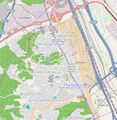
Status on 2012.09.19

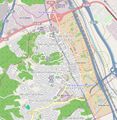
Status on 2013.03.27

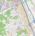
Status on 2014.01.17

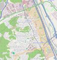
Status on 2014.05.20
