WikiProject Sutton England
(Redirected from Sutton)
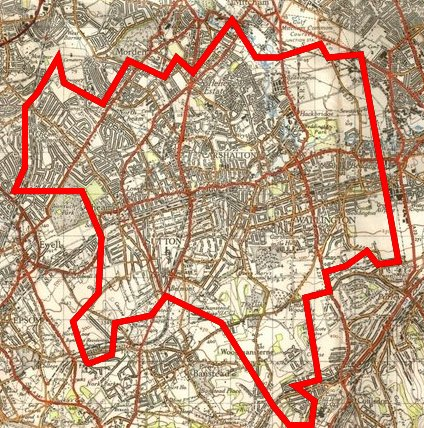
The London Borough of Sutton (map) is 44 sq km in south west London, home to ~180k people and a groundbreaking sustainability initiative called One Planet Sutton which is going to use OpenStreetMap for a lot of its work.
This is the New Popular Edition map of Sutton compared to the current extent of mapping in OpenStreetMap:
We are particularly interested in data on:
- The basic roads for base maps in publications, web sites, etc.
- Routes and facilities for cyclists, pedestrians, buses, trams, trains and car clubs
- Community centres, shops and other key amenities
One Planet Sutton slippy map
Tom Chance and Thomas Wood are working on a nice slippy map of the area and would appreciate help in developing it. See WikiProject Sutton England/OPL map for more info.
Who's Working on the Area
- User:Thomas Wood on Carshalton/Wallington/Beddington/East Sutton
- User:BlueSpecs (Philip Young) on Cheam/South Sutton
- User:TomChance on Hackbridge
- BioRegional will be checking Hackbridge as we go door-to-door, and may eventually be able to check the entire borough this way.
- User:AdrianShort on Stonecot Hill
Public Rights of Way
PROWs are being listed over here, we can only be finished when we have them all...
Completion
| Region | Completion Status | % estimate | Notes |
|---|---|---|---|
| Sutton | Northeast/Southwest areas done to around 80%, town centre needs work. | 80% | |
| Beddington | Complete except for industrial area | 90% | Industrial area recently traced by TimSC |
| Belmont | Mostly complete, one block still requires detailed survey. | 85% | |
| Carshalton | Carshalton village is complete, as is The Wrythe, areas to the north is fairly complete from the party but gets patchier the further north you get. | 70% | |
| Carshalton Beeches/Carshalton-on-the-Hill | Area to north bounded by A232/Railway not surveyed. The rest surveyed by Phil and Tom on 7th June 2008. Brief second pass required to clear up the fixme=*s that still exist.
|
85% | |
| Cheam | South Cheam and Cheam Village complete, North Cheam completed with mapping party. | 95% | Some more tracing of buildings, esp. schools, and bus stops/cycle parking needed. |
| Clockhouse | Now complete since daveemtb finished off Thomas' beginnings. | 95% | |
| Hackbridge | High quality mapping from the party and by TomC. | 99% | Nice buildings on the Felnex Estate! |
| Rosehill | Mostly covered under 'Sutton', areas to the north of the roundabout need surveying. | ? | Partly traced |
| Roundshaw/Purley | Complete | 95% | Ongoing construction work will require another survey soon. Landuse areas needed. |
| Wallington | Roads completed | 90% | Second detail pass required along main roads |
| Worcester Park | Completed by mapping party | 99% |
Notes
- Survey data has been collected for Roundshaw and has yet to be entered into OSM, this part of Sutton will require resurvey in the near future, due to ongoing regeneration works. The variation in the data provided by webmap services is quite amazing - even the OS differs with itself.

