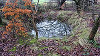
Tag:historic=bomb_crater
Jump to navigation
Jump to search
| Description |
|---|
| A bomb crater |
| Group: historic |
| Used on these elements |
| See also |
| Status: de facto |
| Tools for this tag |
|
A bomb crater may look similar to a natural=sinkhole, but the genesis differs. Some characteristics may help you tell them apart:
- A bomb crater has a more regularly circular rim.
- Part of the matter that a detonation removes from the centre gets deposed at the rim. That makes the rim elevated above the surrounding area until erosion levels it down.
- Bomb craters are steeper at the edge than in the centre.
- Most sinkholes are found in karst or mining areas, while bomb craters are found at former battle fields.
- Former defense lines which are often located at hills were heavily bombarded. You often find bomb craters near the remains of defensive structures such as trenches. Furthermore, bomb craters are found in former war zones near railway lines or bridges.
- Bomb craters often come in groups that span across areas independently from geological faults.
How To Map
Create a node or area and tag it with historic=bomb_crater.
Useful combinations:
- depth=*
- start_date=*
Rendering
Bomb craters are rendered in the historical objects map.
Tag history
This tag does not have a proposal, but it has an obvious meaning and it is somewhat in use in various places of the Earth (see taginfo or overpass turbo).
Similar tags
LOADING TAG LIST...
