Tag:historic=creamery
.jpg) |
| Description |
|---|
| A creamery is an industrial building where butter and sometimes cheese or ice-cream were made from milk. For rural communities, it also served as a social gathering point. |
| Group: historic |
| Used on these elements |
| Requires |
|
| Useful combination |
|
| Status: approved |
| Tools for this tag |
Creamery buildings, even if disused, will often be remembered by locals under their old purpose. Placenames such as "Creamery Lane" might hint at its former use. They can often be recognized by their loading ramp and sometimes still feature a chimney. In some cases, a local historical group or similar institution might have erected a memorial=plaque in its memory.
Usage
The tag historic=creamery can be used to map historic sites of creameries, where the building is still intact or in ruins. If there is no physical trace, please use openhistoricalmaps.org instead. If there is only a commemorative plaque for the creamery, please only map it as such (memorial=plaque).
If the building is repurposed, use building:use=* with the equivalent value. If the building is abandoned, use abandoned=yes.
Examples
-
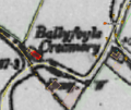 Ballyfoyle Creamery, Co. Kilkenny, Ireland on the British War Office map
 -
![A photograph of Bruree Creamery in County Limerick, Ireland during the 1920s, at which time it was frequently the site of a "Soviet". Seemingly anti Anglo-Irish Treaty graffiti appears on the wall but is obscured by workers posing in front of it[1]](https://upload.wikimedia.org/wikipedia/commons/thumb/d/d8/Bruree_Creamery.jpg/120px-Bruree_Creamery.jpg) A photograph of Bruree Creamery in County Limerick, Ireland during the 1920s, at which time it was frequently the site of a "Soviet". Seemingly anti Anglo-Irish Treaty graffiti appears on the wall but is obscured by workers posing in front of it[1]
A photograph of Bruree Creamery in County Limerick, Ireland during the 1920s, at which time it was frequently the site of a "Soviet". Seemingly anti Anglo-Irish Treaty graffiti appears on the wall but is obscured by workers posing in front of it[1] -
 Creamery building in Timoleague, Co. Cork
 -
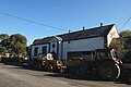 Co-op creamery in Ballingarry, Co. Tipperary (disused)
 -
 Co-op creamery in Callan, Co. Kilkenny (opened 1899)
 -
 Brandonvale Co-op creamery in Graiguenamanagh, Co. Kilkenny (opened 1916). Re-opened as a pharmacy in September 2021.
 -
 The Old Creamery at Tarff, Twynholm, Scotland
 -
![Bladnoch Creamery. Bladnoch Creamery established by the Scottish Co-operative Wholesale Society in 1899 was the largest employer in the Wigtown area and in continuous operation for the longest time of any of the businesses in the village. It soon became a site of many buildings and produced its own Bluebell margarine, as well as making cheese, butter and cooking fat. Its closure in the late 1980s was a major blow to the local area of Wigtown. It is now home to an industrial site and renamed Bladnoch Bridge Estate.[2]](https://upload.wikimedia.org/wikipedia/commons/thumb/3/32/Bladnoch_Creamery_%28geograph_2969426%29.jpg/120px-Bladnoch_Creamery_%28geograph_2969426%29.jpg) Bladnoch Creamery. Bladnoch Creamery established by the Scottish Co-operative Wholesale Society in 1899 was the largest employer in the Wigtown area and in continuous operation for the longest time of any of the businesses in the village. It soon became a site of many buildings and produced its own Bluebell margarine, as well as making cheese, butter and cooking fat. Its closure in the late 1980s was a major blow to the local area of Wigtown. It is now home to an industrial site and renamed Bladnoch Bridge Estate.[2]
Bladnoch Creamery. Bladnoch Creamery established by the Scottish Co-operative Wholesale Society in 1899 was the largest employer in the Wigtown area and in continuous operation for the longest time of any of the businesses in the village. It soon became a site of many buildings and produced its own Bluebell margarine, as well as making cheese, butter and cooking fat. Its closure in the late 1980s was a major blow to the local area of Wigtown. It is now home to an industrial site and renamed Bladnoch Bridge Estate.[2]

![A photograph of Bruree Creamery in County Limerick, Ireland during the 1920s, at which time it was frequently the site of a "Soviet". Seemingly anti Anglo-Irish Treaty graffiti appears on the wall but is obscured by workers posing in front of it[1]](/wiki/File:Bruree_Creamery.jpg)


![Bladnoch Creamery. Bladnoch Creamery established by the Scottish Co-operative Wholesale Society in 1899 was the largest employer in the Wigtown area and in continuous operation for the longest time of any of the businesses in the village. It soon became a site of many buildings and produced its own Bluebell margarine, as well as making cheese, butter and cooking fat. Its closure in the late 1980s was a major blow to the local area of Wigtown. It is now home to an industrial site and renamed Bladnoch Bridge Estate.[2]](/wiki/File:Bladnoch_Creamery_(geograph_2969426).jpg)
- creameries as listed monuments in Ireland (with more photographic examples)
- creameries as listed buildings in England
.jpg)