Tag:historic=lavoir
Jump to navigation
Jump to search
 |
| Description |
|---|
| A disused lavoir mapped for its historical value. |
| Group: historic |
| Used on these elements |
| Useful combination |
|
|
| See also |
| Status: in use |
| Tools for this tag |
A lavoir is a public place for washing laundry manually, i.e. by hand. Many of the disused ones are part of the heritage of a town or village and have been restored to teach visitors about this laboursome way of dealing with laundry.
How to map
Add a node or draw the area of the washing place and add historic=lavoir. Depending on the circumstances, you might need to add a building=* tag.
There might also be tourism=information boards nearby which would be useful to map.
Many wash houses are recorded on Wikimedia (Category:Wash houses), so it might be worth checking there and adding the wikimedia_commons=* for the wash house/ lavoir.
Gallery
-
 Lavoir de Calleville, Charluber, CC BY-SA 4.0, via Wikimedia Commons
 -
 à Noailhac (Corrèze), Marianne Casamance, CC BY-SA 4.0, via Wikimedia Commons
 -
 Old wash houses in Tigeaux, Davric, CC BY-SA 4.0, via Wikimedia Commons
 -
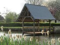
 Hyppolyte de Saint-Rambert, CC BY 4.0, via Wikimedia Commons


_Lavoir_et_fontaines_hdsr_VLux5_947.jpg)
See also
amenity=lavoirfor still in use placesamenity=washing_machinefor self-service machinesshop=laundryfor a place that offers the service or self-service of washing your clothes with washing machines