Tag:natural=gulf
Jump to navigation
Jump to search
 |
| Description |
|---|
| A gulf is a portion of the ocean that penetrates land. |
| Group: water |
| Used on these elements |
| Requires |
|
| Useful combination |
| See also |
| Status: undefined |
| Tools for this tag |
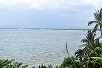
A gulf is an inlet of a sea which is mostly surrounded by land, but with a level connection to the ocean.
Gulfs often have calmer waters than the surrounding sea, due to the surrounding land blocking some waves and often reducing winds. Gulfs can also exist within a lake or pond.
A gulf is a portion of the ocean that penetrates land. Gulfs vary greatly in size, shape, and depth. They are generally larger and more deeply indented than bays. Like bays, they often make excellent harbors. Many important trading centers are located on gulfs.
A gulf is also similar to a bay but deeper water-level.