Tag:waterway=soakhole
Jump to navigation
Jump to search
 |
| Description |
|---|
| The point at which a river or stream percolates into or through the soil |
| Group: waterways |
| Used on these elements |
| Status: imported |
| Tools for this tag |
|
Imported from source where it was described as "The point at which a river or stream percolates into or through the soil".
Nearly all uses are from New Zealand import and most of them are NOT attached to any waterway, despite the definition. This is probably due to the interesting idea of importing these separately from their associated watercourses. The corresponding import of streamlines is less than 5% complete, so most of them are not yet connected.
Examples
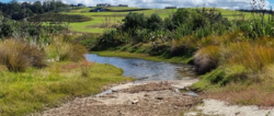
 An example of a natural soakhole at the end of a small stream

See also
- natural=sinkhole
- waterway=stream_end with a similar meaning