User:Andygates
| About Me | |||||||||
|---|---|---|---|---|---|---|---|---|---|
| |||||||||
| GARMIN DOWNLOAD: I have a fresh (updated most weeks, midweek) Garmin build for UK & Ireland OSM data (routable) plus SMC contours to give a UK & IE OSM Topo for Garmin. It's available here: http://www.ravenfamily.org/andyg/maps Munky - a richer style with many more POI, cycleway blazing, better POI text, etc. |
Triathlete geek lurking in Crediton, Devon, UK. Recently got a blow-up kayak for geohashing. :)
Handy link for my own reference: Orienteering map style guide: [1]
How I do that Garmin Map
Alex asked how I did the map, and I may as well paste in my reply as it's a handy seed for Garmin-dabbling:
There's a community tool called mkgmap which turns OSM data into Garmin maps. Basically, I just run that with my own set of style files.
First I download the OSM data for the areas I'm interested in from Geofabrik: http://download.geofabrik.de/osm/europe/
Then I have to use the mkgmap splitter tool to chew the data into small enough tiles for my clockwork laptop to process: http://www.mkgmap.org.uk/page/tile-splitter (if you've a modern machine, or are doing limited areas, you may not need to do this).
Then I run mkgmap, referencing my style-files. There are a bunch of text files in the mkgmap/resources/styles folders (create your own folder from the default and play). You can specify, for example, shop=bicycle and give it a Garmin object code (that's the [scaryhex] part).
The other file that's needed is a TYP-file, which is up on my site and was edited with this tool: http://ati.land.cz/gps/typdecomp/editor.cgi ; here, custom stuff is given the same Garmin codes and that's how the visual styling is done. You can upload little transparent GIFs (like the traffic light or postbox) and draw line and fill textures in the editor.
Think of the TYP file as a CSS for maps.
The mkgmap run will create a bunch of .IMG files. They need to be rolled up into a useable map: I use Sendmap (http://www.cgpsmapper.com/) and you have to include the TYP file here, too. (Tip: Put the TYP in first, and generation seems more reliable)
Sendmap lets you roll together arbitrary IMG files, so I add some pre-generated contour lines at this point.
...and that produces the GMAPSUPP.IMG we know and love.
So the chain runs:
1: Get OSM data. 1a: Fuss the data into bite-size chunks. 2: Run mkgmap with your style and TYP files. 3: Run sendmap with your TYP file and any extra IMG files.
Once you've got everything running as you like, it's pretty easy to chain up a bunch of little scripts to do it automatically.
Current mapping interests:
(mostly just updatey bits, Devon town detail, and the dreaded waterways of the Somerset levels)
- Did lots of Haiti mapping.
- I'm interested in making a renderer that builds EPUB atlases for readers (yes, I got a reader for Christmas ;) ). There's an interesting navigational challenge here. Maybe draw detail centered around major POI (settlements, etc) and then build an index page; also an overview of the area.
- Picking off the little villages and footpaths as an excuse to get out for bike and run training, and making That Perfect Style so that the Garmin extracts are rich without being cluttered, gorgeous without being fussy.
Routes I'm working on:
- Two Moors Way 228450
 228450
 - East Devon Way 272293
 272293
 - Ridgeway 8879
 8879
8879 - Exeter Green Circle 272308
 272308
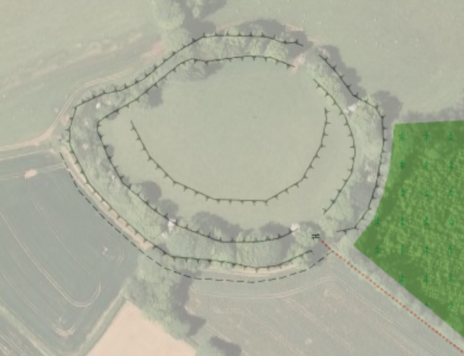
Here's Cadbury Castle, walked and then tagged with man_made=embankment, overlaid on Google Earth to show how accurate a wandering goon with a vanilla GPS unit can be!
-- Check the Diary for more diary stuff....
24 july - mapped Sandford. Have been busy with long bike rides and adding bits and pieces...
24 May - Mapped Kenton and some Dartmoor stuff around Meldon.
13-Mar-02009: Been polishing my routable Garmin to the point where it's a single-click to download fresh data, build the maps, upload them and tweet about it. Also: micromapping at work, getting the buildings right.
23-Feb-02009: Wrestled with the toolchain to get a routable UK & Ireland map. Preliminary tests are filled with win. Props to the osm2mp and mkgmap coders, this really makes OSM prime-time on Garmin!
14-Feb-02009: Copplestone done in detail.
07-Feb-02009: Newton St Cyres north side.
24-Jan-02009: The south side of Newton St Cyres. North side yet to do.
18-Jan-02009: Stoke Woods by foot, getting all those paths. Very muddy!
17-Jan-02009: My first micromapping bike ride, to get Newbuildings done. Can't believe that I lived there for years and still learned stuff just in an hour! JOSM'd up and lovely.
