User:Monxton/Route planning for eTrex 30
I'm considering the options for navigating my upcoming cycle tour. Personal notes, because this information is scattered around the wiki. If it is useful for you, so much the better.
The map currently on my eTrex 30 is a personalised OpenFietsMapLite (see Garmin.OpenStreetMap.nl#Openfietsmap_Lite), but any routable map should be OK.
Tracks and Routes
Options for navigating a prepared route on the eTrex 30:
- navigate a Track
- The eTrex 30 supports tracks of up to 10,000 trackpoints, which is way more detail than you could possibly need for one day's cycling. The track is overlaid on the map in your chosen colour, and the map can be oriented "Track Up" so that it is always ahead of you. The device can give an audible signal as you pass through trackpoints, but there is no real turn-by-turn navigation. The track loads up quickly.
- navigate a Direct Route
- This is what Garmin confusingly call "Off-Road" routing in the menus. The routing is done without reference to any loaded map, you just see a straight line between each pair of routepoints. Again there is no real turn-by-turn navigation. The eTrex 30 supports routes with up to 250 routepoints. This may require some reduction in the total number of points in the route creation tool, but it is still a tolerable limit for one day's cycling. If the route is very detailed, you could also consider dividing it into a number of shorter sections, each with 250 routepoints.
- navigate an Auto Route
- This is what Garmin call "On Road for Time / On Road for Distance" in the menus. It is in this mode that the Garmin springs into life with its turn-by-turn directions. These are very helpful in unfamiliar places, but there are some problems:
- There is a limit of 50 routepoints per route in this mode. This is inadequate to sufficiently specify a route. The Garmin uses your loaded map to route you between the routepoints. It honours the routing parameters you specified in the setup (e.g. route for bicycle, avoid unpaved roads and so on), but even so, it is almost certain that the route it chooses between the routepoints will not be exactly what you intended. The difference may be trivial, or it may be significant.
- The route takes an age to load up. Even when it has loaded, the software seems slightly fragile, and can crash or hang so that you have to reboot the device.
Of course it is also possible to use the device and the loaded map to navigate without a prepared route, but that's not the subject of this page.
I like to have the turn-by-turn directions when travelling in unfamiliar territory. So often I adopt the belt-and-braces approach of using a 50-point autoroute, but also displaying the detailed track on the map, in a different colour. That way you get both the turn-by-turn directions and the reliability of the track.
Example Screenshots
-
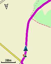 Navigating a track. Track points with small directional arrows are visible on the map.
 -
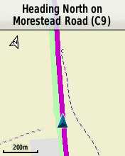 Guidance text while navigating a track, turned on from Map-> Setup-> Guidance Text. Not as helpful as turn-by-turn directions.
 -
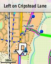
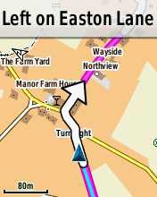 Turn-by-turn routing through a junction (AutoRoute mode).
 -
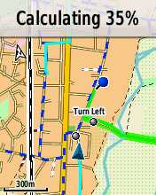 AutoRoute takes a long time to calculate.
 -
 Going off-route.


Websites for Route Preparation
Note that although the Etrex 30 supports 10,000 trackpoints per track, I also need to prepare tracks for a fellow traveller with an eTrex Vista, with a 500-trackpoint limit. The reduction to 500 trackpoints can be done in a separate program, such as GPSBabel, but it would be desirable to avoid this extra step if possible.
- BikeHike
- My former preferred site, when I was mostly using a Garmin Edge 605. AFAIK this was the only site that did a good job of creating the GPXX format for the 605/705, but that's irrelevant to the eTrex 30. Plus it supported British Ordnance Survey maps (yes, I do know this is the OSM wiki...). It could export various formats, and could reduce the number of points to a defined limit. However the OSM routing service there no longer works, so I have abandoned it and auditioned some alternatives...
- Cycle Travel
- Looks lovely, but so far only supports the UK, which is not the destination of my next tour, so haven't investigated further.
- BikeRouteToaster
- Works with various OSM renderings including OpenCycleMap, also Google maps. Configurable screen layout, useful options for type of route, but map does not move automatically with current position of the pointer. The export option it calls "GPX" creates a Track, including elevation data; doesn't appear to be able to export a Route, or to limit the number of trackpoints.
- RideWithGPS
- Works with Google maps, Mapnik or OpenCycleMap. Not much router configurability, but it agreed with me on my test route, so that's OK. Map follows cursor. Can export a Track, including elevation data; doesn't appear to be able to export a Route, or to limit the number of trackpoints.
- GPSies
- Looks kind-of crummy, and has a lot of ads, but it has a fullscreen mode which gets rid of them. Uses GraphHopper as a router. Wide choice of maps, with optional overlays including Waymarked Trails: Cycling; I prefer this to the OpenCycleMap. Has an option for the map to follow the cursor. Can export a track, including elevation data. Can also export a Route, and can reduce the number of routepoints or trackpoints to a maximum you specify.
On this basis I am going with GPSies to prepare the navigation for my upcoming tour.