User:PeterPan99
Rationale for road naming in North Eaglestone
I was unsure how to tag some roads near me. The challenge was that 5 physical roads share only 4 names. The OSM database had a Map Note near to one of them, saying that the name was wrong, so I thought I would sort it out.
These “roads” are all bits of tarmac surface that you can (and are allowed to) drive a car on (or cycle on, etc.) and each is a dead end (cul de sac), off a common tertiary road.
Research
I have consulted:
a. The local council’s public website map,
b. https://www.findmystreet.co.uk/map (which shows USRNs) and even...
c. Google Maps
for clues.
However, they agree on only 4 out of the 5 roads, which does not sound too bad until….(see next paragraph…).
I know that I should “map what I see on the ground”, so I visited the site, but that did not really help, because it differs again from what ANY of the maps show and it is a mess. Two of the roads each have 2 names on signs (illustrations below) and 3 of the names are each used twice, on different roads.
In more detail…
| Road | Council | FindMyStreet (USRN) | Google Maps | Existing OSM | Survey | Solution |
|---|---|---|---|---|---|---|
| A | Harrier Court | Harrier Court (25801069) | Harrier Court | Harrier Court | Harrier Court | Harrier Court |
| B | Harrier Court | Not mapped, but raster background shows “Harrier Court” | High Trees | High Trees | High Trees | Service road (with no name) |
| C | High Trees | High Trees (25801072) | High Trees | North Ridge | High Trees / North Ridge | High Trees |
| D | North Ridge | North Ridge (25801077) | North Ridge | Ferndale | Ferndale / North Ridge | North Ridge |
| E | Ferndale | Ferndale (25801063) | Ferndale | Ferndale | Ferndale | Ferndale |
Concerns and constraints
I do not know how to tag a single road with 2 different names of equal stature. (They are NOT “Thoroughfare” and “Dependent Thoroughfare” and are NOT signed “Road A, leading to Road B”). Also, I am not happy tagging 2 separate roads with the same name, even if they are only less than 200 metres apart.
Assessment and solution
Road A and Road E are relatively easy and uncontroversial.
Road B can be tagged as a service road, with no name. (There are no houses directly fronting onto it and most traffic is going to and from the car park near the local shops.)
Roads C and D should be named with only one of the names on the sign board.
Result
One road is left without a name, but that is (arguably) a service road.
No roads have more than one name
No names are used on more than one road.
The OSM naming now follows the allocation of USRNs.
Reflection
The issue is caused by the roads having no houses directly fronting onto them (only garages) and the names really being associated with terraces of houses lying between the roads and served only by footpaths.
Illustrations
-
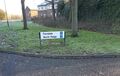 A road sign with 2 names
 -
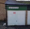 Signage within a street

