User:TrekClimbing
I'm Tom and I map lots of kinds of things, mainly around Guiseley in West Yorkshire.
Mapping landcover
I think a lot of the land around me is marginal/transitional, making mapping the landcover (natural/landuse) tricky. I'm also uncertain where to draw the lines between grassland/heath/scrub/wood in some cases, which doesn't help! So I'm going to dump some photos here. This is a work in progress.
Transitional land
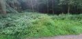
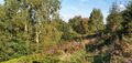
New plantation at Norcroft / The Odda
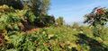
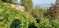
This area has been recently planted with small trees and fenced off from the sheep. I've mapped this part as scrub. There was already plenty of gorse here as can be seen, and parts near the track downhill (to the north) are quite pludgey underfoot and should be mapped as wetland. There is also an older, taller section of woody plants (no photos yet) currently mapped as wood. This might be better as scrub as it's comparatively low (although still over head height) and rather dense. The grazed areas are mapped as meadow which renders appropriately green but doesn't communicate the upland nature of them.
-
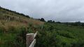 looking West along the fenceline dividing new plantation on the left from grazed upland on the right
 -
 Downhill from a newly planted area towards a wet, grazed area with gorse
 -
 Scrubby wet grazed area below the fenceline


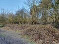
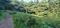
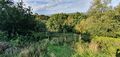
Former field near woodland and railway line
This former field - it no longer seems to be grazed or mown being too small, steep and muddy for modern farming - is between a bluebell wood (Sodhall Hill wood) and traintrack. It's mapped as grassland (although it's not very diverse) with a scrub margin, wood beyond and some individual trees along the boundary.
-
 View south-east from Springs Road across a nettly/brambly patch, between trees at the field boundary to former field
 -
 Trees and brambles currently mapped as wood and scrub
 -
 Brambles and scrubby trees (trees (over the fence) unmapped but should probably be scrub)
 -
 View North from within the field to the brambly margin


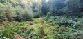
Caley crag boulders
This area is mapped as heath currently. It's mainly bracken with the dreaded Himalayan balsam and some small trees such as Rowan.
-
 Bracken with a Rowan foreground
 -
 Looking south (up) towards trees at the (unmapped) former quarry edge
 -
 Bracken, birch and rowan (and himalayan balsam)
 -
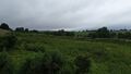
 View uphill from the A660 beyond the margin of trees showing bracken and small trees


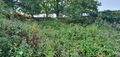
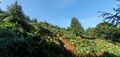
Archaeological sites in Chevin Forest Park
There are a couple of archaeological sites in the western half of Chevin Forest Park 12that serve as breaks in the trees. They are generally a tangle of grass, bracken, brambles and Himalayan balsam.
-
 Bracken, brambles and grass. Small trees at the margin
 -
 Site 2, view north-west of the path
 -
 Site 2, view south of the path


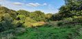
Heath on the Chevin, now being overtaken?
Some patches of what I believe was open heath on the Chevin now have quite a few trees colonising the area.
-
 Birch and rowan trees in among the heather
 -
-
 A patch of grass among the heather and bushes
 -
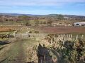
 View from the top path of the Chevin over the heath with lots of scrub


Yorkgate Quarry
A disused quarry (itself unmapped) on the Chevin, next to Beacon Hill is mapped as heath, and there is some heather and gorse, but it's mainly grass.


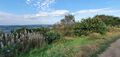
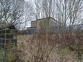
Suburban scrub and wood
I'm reasonably confident with this patch of suburban scrub, wood and grass.
-
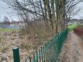
 Suburban scrub and wood, looking West
 -
 Suburban scrub, wood and mown grass, looking East


To add
Other areas of scrub / wood (Parkinson's park, back of Westgate retail park, Yorkgate quarry bank...)
Heath/grassland/scrub at Parkinson's park.
Former hedges - how to map. Tree row? Scrub? Hedge? etc.