Zh-hans:Planet.gpx
Jump to navigation
Jump to search
planet.gpx是与 planet.osm 一起提供的新数据下载,这次包含 OpenStreetMap 保存的所有 GPS 数据。现在最新版本是2013年的
https://planet.openstreetmap.org/gps/
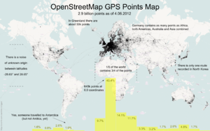
这是 OpenStreetMap 前七年半收集的 GPS 点数据。这是一个非常大的点集合,而且是非常原始的数据。有关如何添加此内容的信息,请参阅 Upload。
- 压缩文件大小为7GBytes
- 未压缩时,该文件是一个55GByte的文本文件
- 数据仅由坐标对组成,没有轨道文件或元数据
- 积分由数千名用户贡献
- 积分以数千个不同的轨迹文件的形式贡献
- 数据包含2,770,233,904点
GPS简单转储格式
-900000000,1771882380
-900000000,1293757490
-891154290,1237501070
-877697750,1653442410
-871875000,1589069750
-871875000,1237507350
-843750000,1350007780
...
这些是逗号分隔的简单文本格式的原始纬度/经度坐标。要获得坐标,请将每个数字除以 107。这些点按位置排序,从地球的最东南部 (90 S,180 E) 开始并向西北移动。
提取
Regional extracts are here.
These are updated infrequently, but usually a couple of weeks behind the GPX Planet.
形式
And on this map they're aggregated into hexagons
This map shows GPS density corrected for population
All points are rendered as a scatter plot on a map in 20 levels with subset download feature. Check on UCRStar
处理
- 可用于渲染GPX节点到地图上的Perl脚本。
- 地区性的提取在这里。
- JAVA application that can be used to extract GPX points from the GPS planet file(s) and to export to ESRI 3D Shape Format (works also with the regional extracts), (related blog posts: 1,2,3,4)
- JAVA application that can be used to match the GPS traces to the OSM street network, (cf.: blog of post university of Heidelberg)
